
Topografisk kort Ready Token
Klik på kortet for at se højden.
Om dette kort
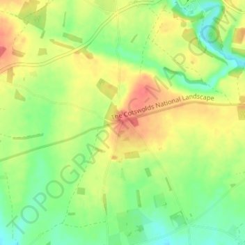
Navn: Topografisk kort Ready Token, højde, terræn.
Gennemsnitshøjde: 125 m
Minimum højde: 99 m
Maksimal højde: 153 m
Andre topografiske kort
Klik på et kort for at se dets topografi, dets højde og dets terræn.
Worcestershire (detached)
United Kingdom > England > Gloucestershire > Cotswold District
Gennemsnitshøjde: 103 m
Cirencester Park
United Kingdom > England > Gloucestershire > Cotswold District > Sapperton
Gennemsnitshøjde: 162 m
Cold Aston
United Kingdom > England > Gloucestershire > Cotswold District > Cold Aston
Gennemsnitshøjde: 189 m
Cirencester
United Kingdom > England > Gloucestershire > Cotswold District
On Cotswold Avenue is the site of a Roman amphitheatre which, while buried, retains its shape in the earthen topography of the small park setting. Cirencester was one of the most substantial cities of Roman-era Britain.
Gennemsnitshøjde: 128 m
Upper Rissington
United Kingdom > England > Gloucestershire > Cotswold District
Gennemsnitshøjde: 208 m
Bourton-on-the-Hill
United Kingdom > England > Gloucestershire > Cotswold District
Gennemsnitshøjde: 200 m
Little Rissington
United Kingdom > England > Gloucestershire > Cotswold District
Gennemsnitshøjde: 171 m
Coberley
United Kingdom > England > Gloucestershire > Cotswold District > Coberley
Gennemsnitshøjde: 234 m
Chipping Campden
United Kingdom > England > Gloucestershire > Cotswold District
Gennemsnitshøjde: 191 m
Moreton-in-Marsh
United Kingdom > England > Gloucestershire > Cotswold District
Gennemsnitshøjde: 135 m
Bushley Muzzard, Brimpsfield
United Kingdom > England > Gloucestershire > Cotswold District > Nettleton > Watercombe
Gennemsnitshøjde: 261 m
Bibury
United Kingdom > England > Gloucestershire > Cotswold District
The parish is approximately rectangular and stretches far to the rolling, elevated, north. It includes on outlying settlement, Ablington, in the upper valley. Bibury Farm is 300 metres (330 yd) from the village, 151 metres (495 ft) above Ordnance Datum (AOD), which is a similar elevation to much of the north.…
Gennemsnitshøjde: 135 m
Botany Bay Wood
United Kingdom > England > Gloucestershire > Cotswold District > Stow-on-the-Wold
Gennemsnitshøjde: 171 m
Baunton
United Kingdom > England > Gloucestershire > Cotswold District > Baunton
Gennemsnitshøjde: 146 m
Somerford Keynes
United Kingdom > England > Gloucestershire > Cotswold District
Gennemsnitshøjde: 92 m
Evenlode
United Kingdom > England > Gloucestershire > Cotswold District > Evenlode
Gennemsnitshøjde: 134 m
Great Rissington
United Kingdom > England > Gloucestershire > Cotswold District > Great Rissington
Gennemsnitshøjde: 168 m
Long Newnton
United Kingdom > England > Gloucestershire > Cotswold District > Long Newnton
Gennemsnitshøjde: 117 m
Bagendon
United Kingdom > England > Gloucestershire > Cotswold District > Bagendon
Gennemsnitshøjde: 171 m
Didmarton
United Kingdom > England > Gloucestershire > Cotswold District > Didmarton
Gennemsnitshøjde: 147 m
Daglingworth
United Kingdom > England > Gloucestershire > Cotswold District > Daglingworth
Gennemsnitshøjde: 169 m
Poulton
United Kingdom > England > Gloucestershire > Cotswold District > Poulton
Gennemsnitshøjde: 109 m
Bourton-on-the-Water
United Kingdom > England > Gloucestershire > Cotswold District
Gennemsnitshøjde: 155 m
Winson
United Kingdom > England > Gloucestershire > Cotswold District > Winson
Gennemsnitshøjde: 145 m
Windrush
United Kingdom > England > Gloucestershire > Cotswold District > Windrush
Gennemsnitshøjde: 155 m
Sherborne
United Kingdom > England > Gloucestershire > Cotswold District > Sherborne
Gennemsnitshøjde: 156 m
Elkstone
United Kingdom > England > Gloucestershire > Cotswold District > Elkstone
Gennemsnitshøjde: 234 m
Down Ampney
United Kingdom > England > Gloucestershire > Cotswold District > Down Ampney
Gennemsnitshøjde: 85 m
Hazleton
United Kingdom > England > Gloucestershire > Cotswold District > Hazleton
Gennemsnitshøjde: 227 m
Chedworth
United Kingdom > England > Gloucestershire > Cotswold District > Chedworth
Gennemsnitshøjde: 187 m
Naunton
United Kingdom > England > Gloucestershire > Cotswold District > Naunton
Gennemsnitshøjde: 201 m
Knap House Quarry, Birdlip
United Kingdom > England > Gloucestershire > Cotswold District > Birdlip
Gennemsnitshøjde: 222 m
Chipping Campden
United Kingdom > England > Gloucestershire > Cotswold District
Gennemsnitshøjde: 191 m
Cirencester
United Kingdom > England > Gloucestershire > Cotswold District
On Cotswold Avenue is the site of a Roman amphitheatre which, while buried, retains its shape in the earthen topography of the small park setting. Cirencester was one of the most substantial cities of Roman-era Britain.
Gennemsnitshøjde: 128 m
Didmarton
United Kingdom > England > Gloucestershire > Cotswold District > Didmarton
Gennemsnitshøjde: 147 m
Cirencester
United Kingdom > England > Gloucestershire > Cotswold District > Chesterton
On Cotswold Avenue is the site of a Roman amphitheatre which, while buried, retains its shape in the earthen topography of the small park setting. Cirencester was one of the most substantial cities of Roman-era Britain.
Gennemsnitshøjde: 128 m