
Giv en donation
Gør dig klar til dit næste eventyr:
Som Amazon-partner tjener denne side en kommission på kvalificerede køb uden ekstra omkostninger for dig.
Topografisk kort Innertkirchen
Klik på kortet for at se højden.
Giv en donation
Gør dig klar til dit næste eventyr:
Som Amazon-partner tjener denne side en kommission på kvalificerede køb uden ekstra omkostninger for dig.
Innertkirchen
The large alpine municipality is located at the confluence of the Urbach and Gadmer streams into the Aare river. It includes the Urbach valley, the Gadmen valley, the Gen valley, the Wetterhorn mountain and the Gauli Glacier. Innertkirchen was created out of the Bäuerten (farming communities) of Grund, Bottigen, Wyler-Schattseite, Wyler-Sonnseite and the agricultural cooperative of Äppigen in 1834. The merger with Gadmen almost doubled the size the municipality. Gadmen lies in the Bernese Oberland with the Susten Pass on the eastern border of the former municipality. The municipal borders stretch from the valley floor, with an elevation of 850–1,250 m (2,790–4,100 ft), up to the nearby mountain peaks at about 3,500 m (11,500 ft). It is located on the border of the Canton of Bern with the Cantons of Obwalden, Nidwalden, Uri and Valais.
Giv en donation
Gør dig klar til dit næste eventyr:
Som Amazon-partner tjener denne side en kommission på kvalificerede køb uden ekstra omkostninger for dig.
Om dette kort
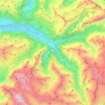
Navn: Topografisk kort Innertkirchen, højde, terræn.
Gennemsnitshøjde: 1.963 m
Minimum højde: 566 m
Maksimal højde: 4.023 m
Giv en donation
Gør dig klar til dit næste eventyr:
Som Amazon-partner tjener denne side en kommission på kvalificerede køb uden ekstra omkostninger for dig.
Andre topografiske kort
Klik på et kort for at se dets topografi, dets højde og dets terræn.
Brienz
Switzerland > Bern > Interlaken-Oberhasli administrative district > Brienz (BE)
Gennemsnitshøjde: 810 m
Gimmelwald
Switzerland > Bern > Interlaken-Oberhasli administrative district
Gennemsnitshøjde: 1.564 m
Jungfrau
Switzerland > Bern > Interlaken-Oberhasli administrative district > Lauterbrunnen
The difference of altitude between the deep valley of Lauterbrunnen (800 m or 2,600 ft) and the summit is particularly visible from the area of Mürren. From the valley floor, west of the massif, the altitude gain is more than 3 km (1.9 mi) for a horizontal distance of 4 km (2.5 mi).
Gennemsnitshøjde: 3.401 m
Giv en donation
Gør dig klar til dit næste eventyr:
Som Amazon-partner tjener denne side en kommission på kvalificerede køb uden ekstra omkostninger for dig.
Schilthorn
Switzerland > Bern > Interlaken-Oberhasli administrative district > Lauterbrunnen
Gennemsnitshøjde: 2.455 m
Hasliberg Wasserwendi
Switzerland > Bern > Interlaken-Oberhasli administrative district
Gennemsnitshøjde: 1.247 m
Eiger
Switzerland > Bern > Interlaken-Oberhasli administrative district > Grindelwald
Gennemsnitshøjde: 2.944 m
Gimmelwald
Switzerland > Bern > Interlaken-Oberhasli administrative district
Gennemsnitshøjde: 1.564 m
Giv en donation
Gør dig klar til dit næste eventyr:
Som Amazon-partner tjener denne side en kommission på kvalificerede køb uden ekstra omkostninger for dig.
Jungfrau
Switzerland > Bern > Interlaken-Oberhasli administrative district > Lauterbrunnen
The difference of altitude between the deep valley of Lauterbrunnen (800 m or 2,600 ft) and the summit is particularly visible from the area of Mürren. From the valley floor, west of the massif, the altitude gain is more than 3 km (1.9 mi) for a horizontal distance of 4 km (2.5 mi).
Gennemsnitshøjde: 3.401 m
Gimmelwald
Switzerland > Bern > Interlaken-Oberhasli administrative district
Gennemsnitshøjde: 1.564 m
Schwarzhoren
Switzerland > Bern > Interlaken-Oberhasli administrative district > Grindelwald
Gennemsnitshøjde: 2.468 m
Männlichen
Switzerland > Bern > Interlaken-Oberhasli administrative district > Grindelwald
Gennemsnitshøjde: 1.709 m
Giv en donation
Gør dig klar til dit næste eventyr:
Som Amazon-partner tjener denne side en kommission på kvalificerede køb uden ekstra omkostninger for dig.
Jungfraujoch
Switzerland > Bern > Interlaken-Oberhasli administrative district > Lauterbrunnen
The Jungfraujoch (German: lit. "maiden saddle") is a saddle connecting two major 4000ers of the Bernese Alps: the Jungfrau and the Mönch. It lies at an elevation of 3,463 metres (11,362 ft) above sea level and is directly overlooked by the rocky prominence of the Sphinx. The Jungfraujoch is a glacier saddle,…
Gennemsnitshøjde: 3.307 m
Underburg
Switzerland > Bern > Interlaken-Oberhasli administrative district > Innertkirchen > Wychel
Gennemsnitshøjde: 912 m
Eiger
Switzerland > Bern > Interlaken-Oberhasli administrative district > Grindelwald
Gennemsnitshøjde: 2.944 m
Horeweid
Switzerland > Bern > Interlaken-Oberhasli administrative district > Därligen
Gennemsnitshøjde: 1.162 m
Giv en donation
Gør dig klar til dit næste eventyr:
Som Amazon-partner tjener denne side en kommission på kvalificerede køb uden ekstra omkostninger for dig.
Wetterhorn
Switzerland > Bern > Interlaken-Oberhasli administrative district > Grindelwald
Gennemsnitshøjde: 2.892 m
Lauenen
Switzerland > Bern > Interlaken-Oberhasli administrative district > Lütschental
Gennemsnitshøjde: 1.360 m
Möösli
Switzerland > Bern > Interlaken-Oberhasli administrative district > Interlaken
Gennemsnitshøjde: 674 m
Harderkulm
Switzerland > Bern > Interlaken-Oberhasli administrative district > Unterseen
Gennemsnitshøjde: 891 m
Giv en donation
Gør dig klar til dit næste eventyr:
Som Amazon-partner tjener denne side en kommission på kvalificerede køb uden ekstra omkostninger for dig.
Jungfraujoch
Switzerland > Bern > Interlaken-Oberhasli administrative district > Lauterbrunnen
The Jungfraujoch (German: lit. "maiden saddle") is a saddle connecting two major 4000ers of the Bernese Alps: the Jungfrau and the Mönch. It lies at an elevation of 3,463 metres (11,362 ft) above sea level and is directly overlooked by the rocky prominence of the Sphinx. The Jungfraujoch is a glacier saddle,…
Gennemsnitshøjde: 3.307 m
Triftsee
Switzerland > Bern > Interlaken-Oberhasli administrative district > Innertkirchen
Gennemsnitshøjde: 2.025 m
Giv en donation
Gør dig klar til dit næste eventyr:
Som Amazon-partner tjener denne side en kommission på kvalificerede køb uden ekstra omkostninger for dig.
Kleine Scheidegg
Switzerland > Bern > Interlaken-Oberhasli administrative district > Lauterbrunnen > Kleine Scheidegg
Gennemsnitshøjde: 2.070 m
Armüli
Switzerland > Bern > Interlaken-Oberhasli administrative district > Interlaken
Gennemsnitshøjde: 690 m
Giv en donation
Gør dig klar til dit næste eventyr:
Som Amazon-partner tjener denne side en kommission på kvalificerede køb uden ekstra omkostninger for dig.
Hübeli
Switzerland > Bern > Interlaken-Oberhasli administrative district > Interlaken
Gennemsnitshøjde: 693 m
Ussers Läger
Switzerland > Bern > Interlaken-Oberhasli administrative district > Oberried am Brienzersee
Gennemsnitshøjde: 1.559 m
Wychel
Switzerland > Bern > Interlaken-Oberhasli administrative district > Innertkirchen
Gennemsnitshøjde: 992 m
Mutthorn
Switzerland > Bern > Interlaken-Oberhasli administrative district > Lauterbrunnen
Gennemsnitshøjde: 2.801 m
Giv en donation
Gør dig klar til dit næste eventyr:
Som Amazon-partner tjener denne side en kommission på kvalificerede køb uden ekstra omkostninger for dig.
Ballenberg
Switzerland > Bern > Interlaken-Oberhasli administrative district > Hofstetten bei Brienz
Gennemsnitshøjde: 774 m
Giv en donation
Gør dig klar til dit næste eventyr:
Som Amazon-partner tjener denne side en kommission på kvalificerede køb uden ekstra omkostninger for dig.
Birg
Switzerland > Bern > Interlaken-Oberhasli administrative district > Lauterbrunnen
Gennemsnitshøjde: 2.311 m
Underburg
Switzerland > Bern > Interlaken-Oberhasli administrative district > Innertkirchen > Wychel
Gennemsnitshøjde: 912 m
Schried
Switzerland > Bern > Interlaken-Oberhasli administrative district > Hofstetten bei Brienz > Hofstetten > Schried
Gennemsnitshøjde: 853 m
Spis
Switzerland > Bern > Interlaken-Oberhasli administrative district > Innertkirchen > Äppigen
Gennemsnitshøjde: 871 m
Giv en donation
Gør dig klar til dit næste eventyr:
Som Amazon-partner tjener denne side en kommission på kvalificerede køb uden ekstra omkostninger for dig.
Teiffental
Switzerland > Bern > Interlaken-Oberhasli administrative district > Brienz (BE) > Axalp
Gennemsnitshøjde: 1.056 m
Unteraargletscher
Switzerland > Bern > Interlaken-Oberhasli administrative district > Guttannen
Gennemsnitshøjde: 2.631 m