
Topografisk kort Observatory Hill
Klik på kortet for at se højden.
Om dette kort
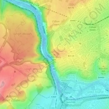
Navn: Topografisk kort Observatory Hill, højde, terræn.
Gennemsnitshøjde: 64 m
Minimum højde: -14 m
Maksimal højde: 136 m
Andre topografiske kort
Klik på et kort for at se dets topografi, dets højde og dets terræn.
Castle Park
United Kingdom > England > City of Bristol > Bristol
The main objection to this plan came from the independent traders who did not wish to relocate because they felt that the proposed new shopping area was 'off the beaten track'. This objection was not unreasonable, as in its pre-war topography Bristol had a long shopping axis that started at Stapleton Road to…
Gennemsnitshøjde: 26 m
Oldbury Court Estate/Vassals Park
United Kingdom > England > City of Bristol > Bristol
Gennemsnitshøjde: 56 m
Brandon Hill Bowling Green
United Kingdom > England > City of Bristol > Bristol
Gennemsnitshøjde: 38 m
Moorgrove Wood
United Kingdom > England > City of Bristol > Bristol > Blaise Hamlet
Gennemsnitshøjde: 40 m