
Giv en donation
Gør dig klar til dit næste eventyr:
Som Amazon-partner tjener denne side en kommission på kvalificerede køb uden ekstra omkostninger for dig.
Topografisk kort Barra da Estiva
Klik på kortet for at se højden.
Giv en donation
Gør dig klar til dit næste eventyr:
Som Amazon-partner tjener denne side en kommission på kvalificerede køb uden ekstra omkostninger for dig.
Om dette kort
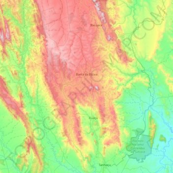
Navn: Topografisk kort Barra da Estiva, højde, terræn.
Gennemsnitshøjde: 716 m
Minimum højde: 257 m
Maksimal højde: 1.550 m
Giv en donation
Gør dig klar til dit næste eventyr:
Som Amazon-partner tjener denne side en kommission på kvalificerede køb uden ekstra omkostninger for dig.
Andre topografiske kort
Klik på et kort for at se dets topografi, dets højde og dets terræn.
Praia do Forte
Brazil > Bahia > Região Metropolitana de Salvador > Mata de São João
Gennemsnitshøjde: 5 m
Giv en donation
Gør dig klar til dit næste eventyr:
Som Amazon-partner tjener denne side en kommission på kvalificerede køb uden ekstra omkostninger for dig.
Chapada Diamantina
The Chapada Diamantina lies at the center of Bahia State and forms the northern part of the Espinhaço Mountain Range. The region is approximately 38,000 km2 (15,000 sq mi) in area and encompasses 58 municipalities. Technically, this region is considered a part of the caatinga biome, and contains some of its…
Gennemsnitshøjde: 1.390 m
Costa do Sauípe
Brazil > Bahia > Região Metropolitana de Salvador > Mata de São João
Gennemsnitshøjde: 10 m
Chapada Diamantina
The Chapada Diamantina lies at the center of Bahia State and forms the northern part of the Espinhaço Mountain Range. The region is approximately 38,000 km2 (15,000 sq mi) in area and encompasses 58 municipalities. Technically, this region is considered a part of the caatinga biome, and contains some of its…
Gennemsnitshøjde: 1.390 m
Giv en donation
Gør dig klar til dit næste eventyr:
Som Amazon-partner tjener denne side en kommission på kvalificerede køb uden ekstra omkostninger for dig.
Chapada Diamantina
The Chapada Diamantina lies at the center of Bahia State and forms the northern part of the Espinhaço Mountain Range. The region is approximately 38,000 km2 (15,000 sq mi) in area and encompasses 58 municipalities. Technically, this region is considered a part of the caatinga biome, and contains some of its…
Gennemsnitshøjde: 1.390 m
Giv en donation
Gør dig klar til dit næste eventyr:
Som Amazon-partner tjener denne side en kommission på kvalificerede køb uden ekstra omkostninger for dig.
Serra do Cipó
Brazil > Bahia > Região Metropolitana de Feira de Santana > Ipecaetá
Gennemsnitshøjde: 254 m
Giv en donation
Gør dig klar til dit næste eventyr:
Som Amazon-partner tjener denne side en kommission på kvalificerede køb uden ekstra omkostninger for dig.
Campos
Brazil > Bahia > Região Administrativa Integrada de Desenvolvimento do Polo Petrolina e Juazeiro > Juazeiro
Gennemsnitshøjde: 387 m
Giv en donation
Gør dig klar til dit næste eventyr:
Som Amazon-partner tjener denne side en kommission på kvalificerede køb uden ekstra omkostninger for dig.
Giv en donation
Gør dig klar til dit næste eventyr:
Som Amazon-partner tjener denne side en kommission på kvalificerede køb uden ekstra omkostninger for dig.