
Topografisk kort Contagem
Klik på kortet for at se højden.
Contagem
The city belongs to the metropolitan mesoregion and to the microregion of Belo Horizonte, has a territorial extension of 195.2 square kilometres (75.4 square miles), and borders the municipalities of Ribeirão das Neves, Esmeraldas, Betim, Ibirité and Belo Horizonte. The elevation of the city hall is 939 metres (3,081 feet).
Om dette kort
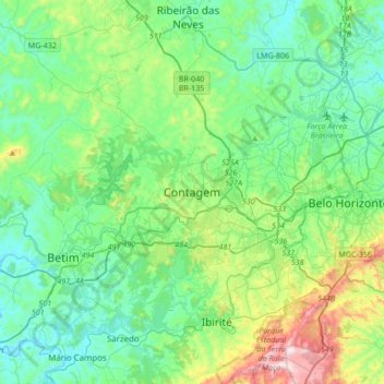
Navn: Topografisk kort Contagem, højde, terræn.
Gennemsnitshøjde: 890 m
Minimum højde: 711 m
Maksimal højde: 1.508 m
Andre topografiske kort
Klik på et kort for at se dets topografi, dets højde og dets terræn.
Parque Industrial
Brazil > Minas Gerais > Região Metropolitana de Belo Horizonte > Contagem
Gennemsnitshøjde: 942 m
Vila Beneves
Brazil > Minas Gerais > Região Metropolitana de Belo Horizonte > Contagem
Gennemsnitshøjde: 897 m
Nova Contagem
Brazil > Minas Gerais > Região Metropolitana de Belo Horizonte > Contagem
Gennemsnitshøjde: 907 m