
Topografisk kort Accrington
Klik på kortet for at se højden.
Accrington
Geographical coordinates: 53° 46' 0" North, 2° 21' 0" West. Height above sea level: there is a spot height outside the Market Hall which is 133.5 metres (438 ft) the benchmark on the side of the neighbouring Town Hall is 441.10 feet (134.45 m). The highest height in the town is 320 metres (1,050 ft) which is in Baxenden and the lowest at the town hall which is at 132.5 metres (435 ft). Accrington is lowering in elevation travelling northwards towards the Hyndburn. North of the river the elevation rises again, crossing over the watershed between Hyndburn and River Calder, both eventually leading into River Ribble via separate routes. The Hyndburn district further north eventually falls to the modest elevation of the Calder river banks.
Om dette kort
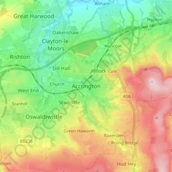
Navn: Topografisk kort Accrington, højde, terræn.
Gennemsnitshøjde: 199 m
Minimum højde: 62 m
Maksimal højde: 408 m
Andre topografiske kort
Klik på et kort for at se dets topografi, dets højde og dets terræn.
Oswaldtwistle Moor
United Kingdom > England > Lancashire > Hyndburn > Green Haworth > Cocker Brook
Gennemsnitshøjde: 300 m