
Giv en donation
Gør dig klar til dit næste eventyr:
Som Amazon-partner tjener denne side en kommission på kvalificerede køb uden ekstra omkostninger for dig.
Topografisk kort Leizhou
Klik på kortet for at se højden.
Giv en donation
Gør dig klar til dit næste eventyr:
Som Amazon-partner tjener denne side en kommission på kvalificerede køb uden ekstra omkostninger for dig.
Om dette kort
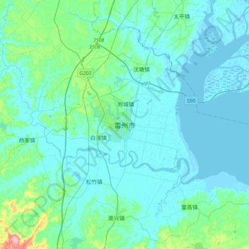
Navn: Topografisk kort Leizhou, højde, terræn.
Sted: Leizhou, Zhanjiang City, Guangdong Province, China (20.75669 109.93178 21.07669 110.25178)
Gennemsnitshøjde: 15 m
Minimum højde: -3 m
Maksimal højde: 137 m
Giv en donation
Gør dig klar til dit næste eventyr:
Som Amazon-partner tjener denne side en kommission på kvalificerede køb uden ekstra omkostninger for dig.
Andre topografiske kort
Klik på et kort for at se dets topografi, dets højde og dets terræn.
Giv en donation
Gør dig klar til dit næste eventyr:
Som Amazon-partner tjener denne side en kommission på kvalificerede køb uden ekstra omkostninger for dig.
Nanshan District
At 587 meters (1,926 ft) tall, Yangtaishan has the highest elevation in the district, with Tanglangshan being the second at 430 meters (1,411 ft), and Nanshan, third, at 336 meters (1,102 ft). The district has a total coastline of 55.18 kilometers (34.29 mi).
Gennemsnitshøjde: 35 m
Giv en donation
Gør dig klar til dit næste eventyr:
Som Amazon-partner tjener denne side en kommission på kvalificerede køb uden ekstra omkostninger for dig.
Giv en donation
Gør dig klar til dit næste eventyr:
Som Amazon-partner tjener denne side en kommission på kvalificerede køb uden ekstra omkostninger for dig.
Giv en donation
Gør dig klar til dit næste eventyr:
Som Amazon-partner tjener denne side en kommission på kvalificerede køb uden ekstra omkostninger for dig.
Giv en donation
Gør dig klar til dit næste eventyr:
Som Amazon-partner tjener denne side en kommission på kvalificerede køb uden ekstra omkostninger for dig.
Fairy Lake
China > Guangdong Province > Luohu District > Liantang Sub-district
Gennemsnitshøjde: 111 m
Jiangmen
A significant amount of historical heritage survives from the period of mass emigration prior to World War II. The most significant are the fortified multi-story towers found mainly in Kaiping. These are known as "Gold Mountain Towers" or diaolou. A number of natural hotspring resorts has been developed…
Gennemsnitshøjde: 31 m