
Giv en donation
Gør dig klar til dit næste eventyr:
Som Amazon-partner tjener denne side en kommission på kvalificerede køb uden ekstra omkostninger for dig.
Topografisk kort Apaña
Klik på kortet for at se højden.
Giv en donation
Gør dig klar til dit næste eventyr:
Som Amazon-partner tjener denne side en kommission på kvalificerede køb uden ekstra omkostninger for dig.
Om dette kort
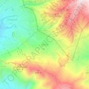
Navn: Topografisk kort Apaña, højde, terræn.
Sted: Apaña, Palca, Pedro Domingo Murillo, La Paz, Bolivia (-16.56680 -68.04368 -16.52680 -68.00368)
Gennemsnitshøjde: 3.924 m
Minimum højde: 3.574 m
Maksimal højde: 4.332 m
Giv en donation
Gør dig klar til dit næste eventyr:
Som Amazon-partner tjener denne side en kommission på kvalificerede køb uden ekstra omkostninger for dig.
Andre topografiske kort
Klik på et kort for at se dets topografi, dets højde og dets terræn.
La Paz
Bolivia > La Paz > Pedro Domingo Murillo
The city, in west-central Bolivia 68 km (42 mi) southeast of Lake Titicaca, is set in a canyon created by the Choqueyapu River. It is in a bowl-like depression, part of the Amazon basin, surrounded by the high mountains of the Altiplano. Overlooking the city is the towering, triple-peaked Illimani. Its peaks…
Gennemsnitshøjde: 3.544 m
Giv en donation
Gør dig klar til dit næste eventyr:
Som Amazon-partner tjener denne side en kommission på kvalificerede køb uden ekstra omkostninger for dig.
La Paz
Bolivia > La Paz > Pedro Domingo Murillo
Located in west-central Bolivia 68 km (42 mi) southeast of Lake Titicaca, La Paz is set in a canyon created by the Choqueyapu River. It is in a bowl-like depression, part of the Amazon basin, surrounded by the high mountains of the Altiplano. Overlooking the city is the triple-peaked Illimani. Its peaks are…
Gennemsnitshøjde: 3.544 m
Giv en donation
Gør dig klar til dit næste eventyr:
Som Amazon-partner tjener denne side en kommission på kvalificerede køb uden ekstra omkostninger for dig.
Mecapaca
Bolivia > La Paz > Pedro Domingo Murillo
Mecapaca Municipality is the second municipal section of the Pedro Domingo Murillo Province in the La Paz Department, Bolivia. Its seat is Mecapaca. It is situated 28 km from the city of La Paz, the capital of the department and the seat of government for the country, and it stands at an elevation of 2,850…
Gennemsnitshøjde: 3.684 m
La Paz
Bolivia > La Paz > Pedro Domingo Murillo
Located in west-central Bolivia 68 km (42 mi) southeast of Lake Titicaca, La Paz is set in a canyon created by the Choqueyapu River. It is in a bowl-like depression, part of the Amazon basin, surrounded by the high mountains of the Altiplano. Overlooking the city is the triple-peaked Illimani. Its peaks are…
Gennemsnitshøjde: 3.544 m
Giv en donation
Gør dig klar til dit næste eventyr:
Som Amazon-partner tjener denne side en kommission på kvalificerede køb uden ekstra omkostninger for dig.
Giv en donation
Gør dig klar til dit næste eventyr:
Som Amazon-partner tjener denne side en kommission på kvalificerede køb uden ekstra omkostninger for dig.
La Paz
Bolivia > La Paz > Pedro Domingo Murillo
The city, in west-central Bolivia 68 km (42 mi) southeast of Lake Titicaca, is set in a canyon created by the Choqueyapu River. It is in a bowl-like depression, part of the Amazon basin, surrounded by the high mountains of the Altiplano. Overlooking the city is the triple-peaked Illimani. Its peaks are always…
Gennemsnitshøjde: 3.544 m
Giv en donation
Gør dig klar til dit næste eventyr:
Som Amazon-partner tjener denne side en kommission på kvalificerede køb uden ekstra omkostninger for dig.
La Paz
Bolivia > La Paz > Pedro Domingo Murillo
The city, in west-central Bolivia 68 km (42 mi) southeast of Lake Titicaca, is set in a canyon created by the Choqueyapu River. It is in a bowl-like depression, part of the Amazon basin, surrounded by the high mountains of the Altiplano. Overlooking the city is the triple-peaked Illimani. Its peaks are always…
Gennemsnitshøjde: 3.544 m
Giv en donation
Gør dig klar til dit næste eventyr:
Som Amazon-partner tjener denne side en kommission på kvalificerede køb uden ekstra omkostninger for dig.
La Paz
Bolivia > La Paz > Pedro Domingo Murillo
Located in west-central Bolivia 68 km (42 mi) southeast of Lake Titicaca, La Paz is set in a canyon created by the Choqueyapu River. It is in a bowl-like depression, part of the Amazon basin, surrounded by the high mountains of the Altiplano. Overlooking the city is the triple-peaked Illimani. Its peaks are…
Gennemsnitshøjde: 3.544 m
Giv en donation
Gør dig klar til dit næste eventyr:
Som Amazon-partner tjener denne side en kommission på kvalificerede køb uden ekstra omkostninger for dig.
Giv en donation
Gør dig klar til dit næste eventyr:
Som Amazon-partner tjener denne side en kommission på kvalificerede køb uden ekstra omkostninger for dig.