
Topografisk kort Acton
Klik på kortet for at se højden.
Om dette kort
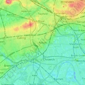
Navn: Topografisk kort Acton, højde, terræn.
Sted: Acton, Greater London, England, W3 9NX, United Kingdom (51.46814 -0.31326 51.54814 -0.23326)
Gennemsnitshøjde: 23 m
Minimum højde: -8 m
Maksimal højde: 82 m
Andre topografiske kort
Klik på et kort for at se dets topografi, dets højde og dets terræn.
London Borough of Richmond upon Thames
United Kingdom > England > Greater London
Gennemsnitshøjde: 18 m
Norwood Grove
United Kingdom > England > Greater London
After Anderson died, ownership passed to the Nettlefold family and subsequently to Frederick Nettlefold the brother of Joseph Nettlefold and a member of the family that founded the Nettlefolds Ltd. engineering firm which later became GKN. Nettlefold is commemorated, as a result of his charitable works, by a…
Gennemsnitshøjde: 58 m
Pymmes Brook
United Kingdom > England > Greater London
Prior to the Anglian glaciation, a "proto-Mole-Wey" river was flowing northwards from the Weald and North Downs, through the "Finchley depression" and Palmers Green, to join the proto-Thames somewhere around Hoddesdon, at what is today an altitude of around 60 metres. It was this river which, during the course…
Gennemsnitshøjde: 41 m