
Topografisk kort Filkins
Klik på kortet for at se højden.
Om dette kort
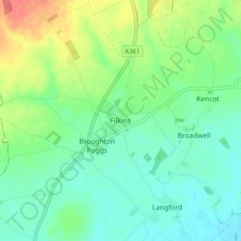
Navn: Topografisk kort Filkins, højde, terræn.
Gennemsnitshøjde: 91 m
Minimum højde: 73 m
Maksimal højde: 130 m
Andre topografiske kort
Klik på et kort for at se dets topografi, dets højde og dets terræn.
Hanborough
United Kingdom > England > Oxfordshire > West Oxfordshire > Church Hanborough
Gennemsnitshøjde: 83 m
Cassington
United Kingdom > England > Oxfordshire > West Oxfordshire > Cassington
Gennemsnitshøjde: 72 m
Stanton Harcourt
United Kingdom > England > Oxfordshire > West Oxfordshire > Stanton Harcourt
Gennemsnitshøjde: 67 m
Great Park
United Kingdom > England > Oxfordshire > West Oxfordshire > Long Hanborough
Gennemsnitshøjde: 94 m
Great Tew
United Kingdom > England > Oxfordshire > West Oxfordshire > Great Tew
Gennemsnitshøjde: 157 m
Milton-under-Wychwood
United Kingdom > England > Oxfordshire > West Oxfordshire
Gennemsnitshøjde: 148 m
Ascott-under-Wychwood
United Kingdom > England > Oxfordshire > West Oxfordshire
Gennemsnitshøjde: 127 m
Minster Lovell
United Kingdom > England > Oxfordshire > West Oxfordshire > Minster Lovell
Gennemsnitshøjde: 112 m
Little Faringdon
United Kingdom > England > Oxfordshire > West Oxfordshire > Little Faringdon
Gennemsnitshøjde: 80 m
South Leigh
United Kingdom > England > Oxfordshire > West Oxfordshire > South Leigh
Gennemsnitshøjde: 80 m
North Leigh
United Kingdom > England > Oxfordshire > West Oxfordshire > North Leigh
Gennemsnitshøjde: 108 m