
Giv en donation
Gør dig klar til dit næste eventyr:
Som Amazon-partner tjener denne side en kommission på kvalificerede køb uden ekstra omkostninger for dig.
Topografisk kort Plans-Mayens
Klik på kortet for at se højden.
Giv en donation
Gør dig klar til dit næste eventyr:
Som Amazon-partner tjener denne side en kommission på kvalificerede køb uden ekstra omkostninger for dig.
Om dette kort
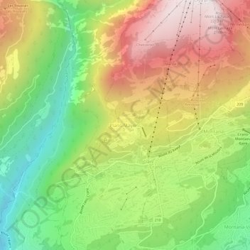
Navn: Topografisk kort Plans-Mayens, højde, terræn.
Sted: Plans-Mayens, Lens, Sierre, Wallis, 3960, Switzerland (46.29356 7.44194 46.33356 7.48194)
Gennemsnitshøjde: 1.501 m
Minimum højde: 870 m
Maksimal højde: 2.224 m
Giv en donation
Gør dig klar til dit næste eventyr:
Som Amazon-partner tjener denne side en kommission på kvalificerede køb uden ekstra omkostninger for dig.
Andre topografiske kort
Klik på et kort for at se dets topografi, dets højde og dets terræn.
Crans-Montana
Switzerland > Wallis > Sierre
The resort is located in the heart of the Swiss Alps in the French-speaking part of the canton of Valais. It is located on a plateau above Sierre at an elevation of about 1,500 m (4,920 ft) above sea level, allowing good view over the Valais Alps and Weisshorn in particular. The resort is a fusion of the two…
Gennemsnitshøjde: 1.660 m
Crans-Montana
Switzerland > Wallis > Sierre
The resort is located in the heart of the Swiss Alps in the French-speaking part of the canton of Valais. It is located on a plateau above Sierre at an elevation of about 1,500 m (4,920 ft) above sea level, allowing a panoramic view over the Valais Alps and Weisshorn in particular. The resort is a fusion of…
Gennemsnitshøjde: 1.660 m
Mollens (VS)
Switzerland > Wallis > Sierre > Crans-Montana
The former municipality is located in the Sierre district, on the right bank of the Rhone river. The municipality stretches from an elevation of 900 to 3,177 m (2,953 to 10,423 ft). It consists of the villages of Mollens and Cordona, the scattered settlements of Conzor, Laques and Saint-Maurice-de-Laques as…
Gennemsnitshøjde: 1.996 m
Giv en donation
Gør dig klar til dit næste eventyr:
Som Amazon-partner tjener denne side en kommission på kvalificerede køb uden ekstra omkostninger for dig.
Randogne
Switzerland > Wallis > Sierre > Crans-Montana
The former municipality is located in the Sierre district, on the northern slope of the Rhone valley. The municipality goes from the Rhone valley at an elevation of 540 m (1,770 ft) to Mont Bonvin at 2,995 m (9,826 ft). It consists of the village of Randogne (which was rebuilt in stone after the destructive…
Gennemsnitshøjde: 1.614 m
Sierre
Switzerland > Wallis > Sierre
The hilly topography of the valley floor derives from a very large postglacial rock avalanche, which collapsed from a fractured scar high to the north.
Gennemsnitshøjde: 1.143 m
Giv en donation
Gør dig klar til dit næste eventyr:
Som Amazon-partner tjener denne side en kommission på kvalificerede køb uden ekstra omkostninger for dig.
Montana
Switzerland > Wallis > Sierre > Crans-Montana
The former municipality is located in the Sierre district, above the right bank of the Rhone. It consists of the villages of Montana and Corin, part of the Champzabé, the hamlet of Diogne as well as the resort of Montana-Vermala (located at an elevation of 1,500 m (4,900 ft) and shared between Montana and…
Gennemsnitshøjde: 1.231 m