
Topografisk kort Telham
Klik på kortet for at se højden.
Om dette kort
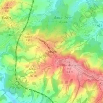
Navn: Topografisk kort Telham, højde, terræn.
Sted: Telham, Rother, East Sussex, England, TN33 0FN, United Kingdom (50.88403 0.49169 50.92403 0.53169)
Gennemsnitshøjde: 68 m
Minimum højde: 9 m
Maksimal højde: 145 m
Andre topografiske kort
Klik på et kort for at se dets topografi, dets højde og dets terræn.
Highwoods SSSI
United Kingdom > England > East Sussex > Rother > Bexhill-on-Sea
Gennemsnitshøjde: 28 m
Rye
United Kingdom > England > East Sussex > Rother > Playden
The town and its striking surroundings have frequently served as subject for painters, many of whose works are now on display in its art gallery. One of the earliest topographical panoramas, dating from the 17th century when the town was still an island port, is in the style of Hendrick Danckerts and on…
Gennemsnitshøjde: 7 m
Rye
United Kingdom > England > East Sussex > Rother
The town and its striking surroundings have frequently served as subject for painters, many of whose works are now on display in its art gallery. One of the earliest topographical panoramas, dating from the 17th century when the town was still an island port, is in the style of Hendrick Danckerts and on…
Gennemsnitshøjde: 7 m