
Topografisk kort Hadleigh
Klik på kortet for at se højden.
Om dette kort
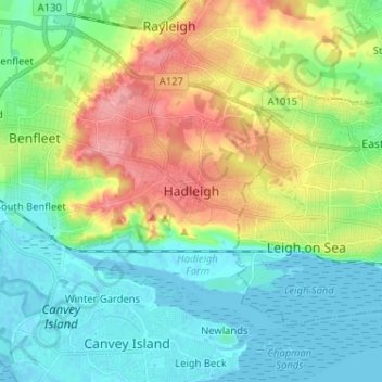
Navn: Topografisk kort Hadleigh, højde, terræn.
Sted: Hadleigh, Castle Point, Essex, England, SS7 2RD, United Kingdom (51.51392 0.56870 51.59392 0.64870)
Gennemsnitshøjde: 29 m
Minimum højde: -1 m
Maksimal højde: 87 m
Andre topografiske kort
Klik på et kort for at se dets topografi, dets højde og dets terræn.
Canvey Island
United Kingdom > England > Essex > Castle Point > Canvey
In 1607 the Elizabethan antiquarian William Camden noted in his work Britannia (a topographical and historical survey of all of Great Britain and Ireland) that Canvey Island (which he called Island Convennon) was documented in the 2nd century by the Alexandrian geographer Ptolemy. In his work Geographia,…
Gennemsnitshøjde: 10 m
Canvey Island
United Kingdom > England > Essex > Castle Point > Canvey Island
In 1607 the Elizabethan antiquarian William Camden noted in his work Britannia (a topographical and historical survey of all of Great Britain and Ireland) that Canvey Island (which he called Island Convennon) was documented in the 2nd century by the Alexandrian geographer Ptolemy. In his work Geographia,…
Gennemsnitshøjde: 10 m