
Giv en donation
Gør dig klar til dit næste eventyr:
Som Amazon-partner tjener denne side en kommission på kvalificerede køb uden ekstra omkostninger for dig.
Topografisk kort Sampit
Klik på kortet for at se højden.
Giv en donation
Gør dig klar til dit næste eventyr:
Som Amazon-partner tjener denne side en kommission på kvalificerede køb uden ekstra omkostninger for dig.
Om dette kort
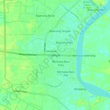
Navn: Topografisk kort Sampit, højde, terræn.
Sted: Sampit, Central Kalimantan, 74322, Indonesia (-2.57891 112.90939 -2.49891 112.98939)
Gennemsnitshøjde: 7 m
Minimum højde: 1 m
Maksimal højde: 13 m
Giv en donation
Gør dig klar til dit næste eventyr:
Som Amazon-partner tjener denne side en kommission på kvalificerede køb uden ekstra omkostninger for dig.
Andre topografiske kort
Klik på et kort for at se dets topografi, dets højde og dets terræn.
South Barito
Indonesia > Central Kalimantan
Regency's topography is flat and low-lying but on the most part except on northern parts where mountain ranges could be found. The regency's low-lying regions are wetlands and swamps with little variations.
Gennemsnitshøjde: 38 m
Giv en donation
Gør dig klar til dit næste eventyr:
Som Amazon-partner tjener denne side en kommission på kvalificerede køb uden ekstra omkostninger for dig.
Giv en donation
Gør dig klar til dit næste eventyr:
Som Amazon-partner tjener denne side en kommission på kvalificerede køb uden ekstra omkostninger for dig.
Giv en donation
Gør dig klar til dit næste eventyr:
Som Amazon-partner tjener denne side en kommission på kvalificerede køb uden ekstra omkostninger for dig.
Palangka Raya
Indonesia > Central Kalimantan
Palangka Raya borders Gunung Mas Regency to the north, Katingan Regency to the west, and Pulang Pisau Regency to the south and east. The area's soil consists mostly of peat and alluvium in its southern part and podzol on the northern part of the city. Overall, podzol soil dominates the city soil with 218,486…
Gennemsnitshøjde: 23 m
Giv en donation
Gør dig klar til dit næste eventyr:
Som Amazon-partner tjener denne side en kommission på kvalificerede køb uden ekstra omkostninger for dig.
Giv en donation
Gør dig klar til dit næste eventyr:
Som Amazon-partner tjener denne side en kommission på kvalificerede køb uden ekstra omkostninger for dig.
Palangka Raya
Indonesia > Central Kalimantan
Palangka Raya borders Gunung Mas Regency to the north, Katingan Regency to the west, and Pulang Pisau Regency to the south and east. The area's soil consists mostly of peat and alluvium in its southern part and podzol on the northern part of the city. Overall, podzol soil dominates the city soil with 218,486…
Gennemsnitshøjde: 23 m
South Barito
Indonesia > Central Kalimantan
Regency's topography is flat and low-lying but on the most part except on northern parts where mountain ranges could be found. The regency's low-lying regions are wetlands and swamps with little variations.
Gennemsnitshøjde: 38 m
Giv en donation
Gør dig klar til dit næste eventyr:
Som Amazon-partner tjener denne side en kommission på kvalificerede køb uden ekstra omkostninger for dig.
Giv en donation
Gør dig klar til dit næste eventyr:
Som Amazon-partner tjener denne side en kommission på kvalificerede køb uden ekstra omkostninger for dig.
Murung Raya
Indonesia > Central Kalimantan
The regency has an area of 23,700 km2 and lies between 114°27'00 to 115°49'00 East longitude and 0°58'30 North latitude to 1°26'00 South latitude. It occupies the valleys and foothills of the southern and eastern slopes of the Müller Mountains, and rises to 1730 m at Mount Lesung on its northern border.…
Gennemsnitshøjde: 365 m
Giv en donation
Gør dig klar til dit næste eventyr:
Som Amazon-partner tjener denne side en kommission på kvalificerede køb uden ekstra omkostninger for dig.
Giv en donation
Gør dig klar til dit næste eventyr:
Som Amazon-partner tjener denne side en kommission på kvalificerede køb uden ekstra omkostninger for dig.
Palangka Raya
Indonesia > Central Kalimantan
Palangka Raya borders Gunung Mas Regency to the north, Katingan Regency to the west, and Pulang Pisau Regency to the south and east. The area's soil consists mostly of peat and alluvium in its southern part and podzol on the northern part of the city. Overall, podzol soil dominates the city soil with 218,486…
Gennemsnitshøjde: 23 m