Geolocate

Topografisk kort Windsor

Klik på kortet for at se højden.

Om dette kort

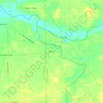
Navn: Topografisk kort Windsor, højde, terræn.

Sted: Windsor, Randolph County, Indiana, 47368, United States (40.13449 -85.23275 40.17449 -85.19275)

Gennemsnitshøjde: 312 m

Minimum højde: 298 m

Maksimal højde: 321 m

Andre topografiske kort

Klik på et kort for at se dets topografi, dets højde og dets terræn.

Farmland

United States > Indiana > Randolph County

Gennemsnitshøjde: 318 m

Lynn

United States > Indiana > Randolph County

Gennemsnitshøjde: 356 m

Parker City

United States > Indiana > Randolph County

According to the 2010 census, Parker City has a total area of 0.57 square miles (1.48 km2), all land. It is located at an elevation of 1025 feet.

Gennemsnitshøjde: 312 m

Winchester

United States > Indiana > Randolph County

Gennemsnitshøjde: 335 m

Modoc

United States > Indiana > Randolph County

Gennemsnitshøjde: 355 m

Ridgeville

United States > Indiana > Randolph County

A post office called Ridgeville has been in operation since 1851. The town was named for its lofty elevation. Joab Ward, an old Settler to Ridgeville since 1819, originally laid out the village of Ridgeville, Randolph County, Indiana in 1854.

Gennemsnitshøjde: 306 m

Saratoga

United States > Indiana > Randolph County

Gennemsnitshøjde: 322 m

Losantville

United States > Indiana > Randolph County

Gennemsnitshøjde: 346 m

Gør dig klar til dit næste eventyr:

🧦Vandresokker - Merinouldsokker der forhindrer vabler og holder fødderne tørre
USB gear til outdoor - Kabler og adaptere til rejsebrug
Letvægtstelt - Kompakt telt ideelt til vandreture og cykelferie
💧Vandfilter - Rens vand fra søer og åer til sikkert drikkevand
🪶Letvægtsudstyr - Gear med lav vægt til langtur

Som Amazon-partner tjener denne side en kommission på kvalificerede køb uden ekstra omkostninger for dig.