
Giv en donation
Gør dig klar til dit næste eventyr:
Som Amazon-partner tjener denne side en kommission på kvalificerede køb uden ekstra omkostninger for dig.
Topografisk kort Goppenstein
Klik på kortet for at se højden.
Giv en donation
Gør dig klar til dit næste eventyr:
Som Amazon-partner tjener denne side en kommission på kvalificerede køb uden ekstra omkostninger for dig.
Om dette kort
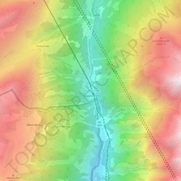
Navn: Topografisk kort Goppenstein, højde, terræn.
Sted: Goppenstein, Ferden, Westlich Raron, Wallis, 3916, Switzerland (46.34814 7.73443 46.38814 7.77443)
Gennemsnitshøjde: 1.923 m
Minimum højde: 1.054 m
Maksimal højde: 2.833 m
Giv en donation
Gør dig klar til dit næste eventyr:
Som Amazon-partner tjener denne side en kommission på kvalificerede køb uden ekstra omkostninger for dig.
Andre topografiske kort
Klik på et kort for at se dets topografi, dets højde og dets terræn.
Blatten
Switzerland > Wallis > Westlich Raron
Blatten lies in the Lötschental valley south of the Bernese Alps. The municipality is located in the Westlich Raron district, and is the highest inhabited part of the Lötschental valley at an elevation of 1,540 m (5,050 ft). It consists of the village of Blatten and the hamlets of Eisten, Ried and…
Gennemsnitshøjde: 2.536 m
Giv en donation
Gør dig klar til dit næste eventyr:
Som Amazon-partner tjener denne side en kommission på kvalificerede køb uden ekstra omkostninger for dig.
Blatten
Switzerland > Wallis > Westlich Raron
Blatten lies in the Lötschental valley south of the Bernese Alps. The municipality is located in the Westlich Raron district, and is the highest inhabited part of the Lötschental valley at an elevation of 1,540 m (5,050 ft). It consists of the village of Blatten and the hamlets of Eisten, Ried and…
Gennemsnitshøjde: 2.536 m