
Topografisk kort Shirland
Klik på kortet for at se højden.
Om dette kort
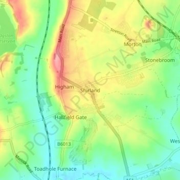
Navn: Topografisk kort Shirland, højde, terræn.
Gennemsnitshøjde: 121 m
Minimum højde: 83 m
Maksimal højde: 177 m
Andre topografiske kort
Klik på et kort for at se dets topografi, dets højde og dets terræn.
Ashover CP
United Kingdom > England > Derbyshire > North East Derbyshire
By the 18th century, there were several thousand acres of unenclosed moorland in the parish of Ashover, principally covered with heath. The only paths across this wilderness for roads were tracks in the sand or heath with here and there a stone post on the hills or elevations to serve as guides to the…
Gennemsnitshøjde: 210 m
Ogston Reservoir
United Kingdom > England > Derbyshire > North East Derbyshire > Woolley Moor
Gennemsnitshøjde: 137 m
Doghole Wood
United Kingdom > England > Derbyshire > North East Derbyshire > Holymoorside
Gennemsnitshøjde: 142 m
Dronfield Nature Park
United Kingdom > England > Derbyshire > North East Derbyshire > Dronfield > Unstone Green
Gennemsnitshøjde: 156 m
Norwood Cottage Lakes
United Kingdom > England > Derbyshire > North East Derbyshire > Killamarsh
Gennemsnitshøjde: 93 m
Grassmoor Country Park
United Kingdom > England > Derbyshire > North East Derbyshire > Corbriggs
Gennemsnitshøjde: 116 m
Holmesfield
United Kingdom > England > Derbyshire > North East Derbyshire > Holmesfield
Gennemsnitshøjde: 233 m