
Giv en donation
Gør dig klar til dit næste eventyr:
Som Amazon-partner tjener denne side en kommission på kvalificerede køb uden ekstra omkostninger for dig.
Topografisk kort Glattbrugg
Klik på kortet for at se højden.
Giv en donation
Gør dig klar til dit næste eventyr:
Som Amazon-partner tjener denne side en kommission på kvalificerede køb uden ekstra omkostninger for dig.
Om dette kort
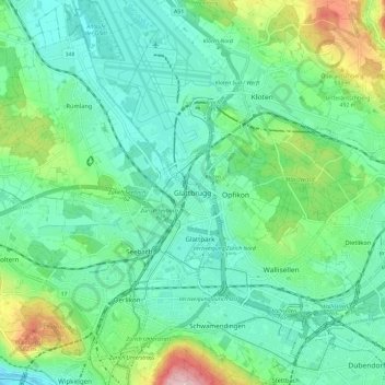
Navn: Topografisk kort Glattbrugg, højde, terræn.
Sted: Glattbrugg, Opfikon, Bezirk Bülach, Zurich, 8152, Switzerland (47.39263 8.52479 47.47263 8.60479)
Gennemsnitshøjde: 459 m
Minimum højde: 400 m
Maksimal højde: 637 m
Giv en donation
Gør dig klar til dit næste eventyr:
Som Amazon-partner tjener denne side en kommission på kvalificerede køb uden ekstra omkostninger for dig.
Andre topografiske kort
Klik på et kort for at se dets topografi, dets højde og dets terræn.
Giv en donation
Gør dig klar til dit næste eventyr:
Som Amazon-partner tjener denne side en kommission på kvalificerede køb uden ekstra omkostninger for dig.
Kloten
Switzerland > Zurich > Bezirk Bülach
Kloten has an oceanic climate (Köppen Cfb), with sizeable continental influences due to its relative elevation and distance to any large bodies of water. Precipitation is high year-round and as a result of the cold winter nights, snowfall is frequent in winter. Due to the mild afternoons, this snow seldom…
Gennemsnitshøjde: 478 m