
Giv en donation
Gør dig klar til dit næste eventyr:
Som Amazon-partner tjener denne side en kommission på kvalificerede køb uden ekstra omkostninger for dig.
Topografisk kort Magadino
Klik på kortet for at se højden.
Giv en donation
Gør dig klar til dit næste eventyr:
Som Amazon-partner tjener denne side en kommission på kvalificerede køb uden ekstra omkostninger for dig.
Om dette kort
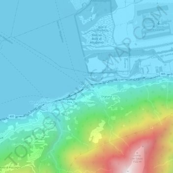
Navn: Topografisk kort Magadino, højde, terræn.
Gennemsnitshøjde: 438 m
Minimum højde: 190 m
Maksimal højde: 1.583 m
Giv en donation
Gør dig klar til dit næste eventyr:
Som Amazon-partner tjener denne side en kommission på kvalificerede køb uden ekstra omkostninger for dig.
Andre topografiske kort
Klik på et kort for at se dets topografi, dets højde og dets terræn.
Locarno
Switzerland > Ticino > Distretto di Locarno
The municipality is the capital of its district. Locarno is located on the left shore of Lake Maggiore. The city is made up of the old town (historic settlement centre), the new town (Nuovo quartiere) toward the lake and the land district (quartiere Campagna) toward Solduno. The area of the municipality…
Gennemsnitshøjde: 604 m
Giv en donation
Gør dig klar til dit næste eventyr:
Som Amazon-partner tjener denne side en kommission på kvalificerede køb uden ekstra omkostninger for dig.
Valle Verzasca
Switzerland > Ticino > Distretto di Locarno > Verzasca
Located between the Leventina and the Valle Maggia valleys, Valle Verzasca extends over a length of 25 kilometres (16 mi) in north–south direction and is situated in the north of the Lago Maggiore. The valley floor is at about 500 metres (1,640 ft) to 900 metres (2,953 ft) above sea level. The surrounding…
Gennemsnitshøjde: 1.398 m