Geolocate

Topografisk kort Três Picos

Klik på kortet for at se højden.

Om dette kort

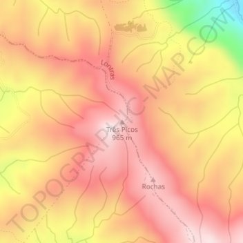
Navn: Topografisk kort Três Picos, højde, terræn.

Sted: Três Picos, Aurora, Região Geográfica Imediata de Rio do Sul, Região Geográfica Intermediária de Blumenau, Santa Catarina, South Region, Brazil (-27.28203 -49.50961 -27.28193 -49.50951)

Gennemsnitshøjde: 795 m

Minimum højde: 476 m

Maksimal højde: 954 m

Andre topografiske kort

Klik på et kort for at se dets topografi, dets højde og dets terræn.

Bom Jardim da Serra

Brazil > Santa Catarina

Gennemsnitshøjde: 969 m

Guaramirim

Brazil > Santa Catarina

Gennemsnitshøjde: 110 m

Canoinhas

Brazil > Santa Catarina

Canoinhas is a Brazilian municipality, in the north plateau of the State of Santa Catarina. Its latitude is 26°10'38" South, its longitude is 50°23'24" West, and its altitude is 839 meters. The population was estimated in 2020 at 54,480 inhabitants.

Gennemsnitshøjde: 818 m

Itaiópolis

Brazil > Santa Catarina

Gennemsnitshøjde: 783 m

Major Gercino

Brazil > Santa Catarina

Gennemsnitshøjde: 418 m

Agrolândia

Brazil > Santa Catarina

In 1880, at the time when the Germans began to colonize the region of Rio do Sul, in an expressionless manner, they also began to populate the municipal territory of Agrolândia. It is possible to mention as the first immigrants to live in the region, the pioneers Leopoldo and Oswaldo Zwicker, Atwig Will and…

Gennemsnitshøjde: 678 m

Pomerode

Brazil > Santa Catarina

Gennemsnitshøjde: 226 m

Rio Negrinho

Brazil > Santa Catarina

Gennemsnitshøjde: 805 m

Paulo Lopes

Brazil > Santa Catarina

Gennemsnitshøjde: 225 m

Blumenau

Brazil > Santa Catarina

Gennemsnitshøjde: 220 m

Florianópolis

Brazil > Santa Catarina

Florianópolis has a native Atlantic Forest-type vegetation. This vegetation has an extremely diverse and unique mix of vegetation and forest types. The main ecoregion is the coastal Atlantic forest, the narrow strip of about 50–100 kilometers (31–62 miles) along the coast which covers about 20 percent of…

Gennemsnitshøjde: 92 m

São José do Cedro

Brazil > Santa Catarina

Gennemsnitshøjde: 613 m

Anitápolis

Brazil > Santa Catarina

Gennemsnitshøjde: 772 m

Florianópolis

Brazil > Santa Catarina

Florianópolis lies within the Atlantic Forest which has an extremely diverse and unique mix of vegetation and forest types. The main ecoregion is the coastal Atlantic forest, the narrow strip of about 50–100 kilometers (31–62 miles) along the coast which covers about 20 percent of the region. This forest…

Gennemsnitshøjde: 92 m

Chapecó

Brazil > Santa Catarina

Gennemsnitshøjde: 575 m

Lages

Brazil > Santa Catarina

Gennemsnitshøjde: 1.011 m

Schroeder

Brazil > Santa Catarina

Gennemsnitshøjde: 339 m

Blumenau

Brazil > Santa Catarina

Gennemsnitshøjde: 220 m

São Martinho

Brazil > Santa Catarina > Tubarão

Gennemsnitshøjde: 80 m

Navegantes

Brazil > Santa Catarina

Gennemsnitshøjde: 11 m

Itajaí

Brazil > Santa Catarina

Gennemsnitshøjde: 41 m

Garopaba

Brazil > Santa Catarina

Gennemsnitshøjde: 44 m

Joinville

Brazil > Santa Catarina

Joinville has a humid subtropical climate (Cfa in the Köppen climate classification data). In some rare cases, Joinville gets hit by South Atlantic cyclones, the most notable being Cyclone Catarina in 2004. Although Joinville lies outside the tropic zone, because of its low altitude and proximity to the…

Gennemsnitshøjde: 162 m

Rio do Sul

Brazil > Santa Catarina

Gennemsnitshøjde: 507 m

Ilhota

Brazil > Santa Catarina

Gennemsnitshøjde: 67 m

Praia da Barra

Brazil > Santa Catarina > Garopaba

Gennemsnitshøjde: 4 m

Saudade

Brazil > Santa Catarina > Biguaçu

Gennemsnitshøjde: 79 m

Joinville

Brazil > Santa Catarina

Joinville has a humid subtropical climate (Cfa in the Köppen climate classification data). In some rare cases, Joinville gets hit by South Atlantic cyclones, the most notable being Cyclone Catarina in 2004. Although Joinville lies outside the tropic zone, because of its low altitude and proximity to the…

Gennemsnitshøjde: 162 m

Praia Brava

Brazil > Santa Catarina > Itajaí

Gennemsnitshøjde: 45 m

Mafra

Brazil > Santa Catarina

Gennemsnitshøjde: 855 m

Porto Belo

Brazil > Santa Catarina

Gennemsnitshøjde: 19 m

Vargem Bonita

Brazil > Santa Catarina

Gennemsnitshøjde: 1.047 m

Saudades

Brazil > Santa Catarina

Gennemsnitshøjde: 428 m

Joinville

Brazil > Santa Catarina

Joinville has a humid subtropical climate (Cfa in the Köppen climate classification data). In some rare cases, Joinville gets hit by South Atlantic cyclones, the most notable being Cyclone Catarina in 2004. Although Joinville lies outside the tropic zone, because of its low altitude and proximity to the…

Gennemsnitshøjde: 162 m

Imbituba

Brazil > Santa Catarina

Gennemsnitshøjde: 26 m

Balneário Camboriú

Brazil > Santa Catarina

Gennemsnitshøjde: 41 m

Luiz Alves

Brazil > Santa Catarina

Gennemsnitshøjde: 187 m

Chapecó

Brazil > Santa Catarina

Gennemsnitshøjde: 562 m

Herval d'Oeste

Brazil > Santa Catarina

Gennemsnitshøjde: 720 m

Ituporanga

Brazil > Santa Catarina

Gennemsnitshøjde: 565 m

Florianópolis

Brazil > Santa Catarina

Florianópolis lies within the Atlantic Forest which has an extremely diverse and unique mix of vegetation and forest types. The main ecoregion is the coastal Atlantic forest, the narrow strip of about 50–100 kilometers (31–62 miles) along the coast which covers about 20 percent of the region. This forest…

Gennemsnitshøjde: 92 m

São João do Oeste

Brazil > Santa Catarina

Gennemsnitshøjde: 372 m

Garuva

Brazil > Santa Catarina

Gennemsnitshøjde: 321 m

Palhoça

Brazil > Santa Catarina

Gennemsnitshøjde: 209 m

Urubici

Brazil > Santa Catarina

The town of Urubici was founded in 1915, as the village of São Joaquim. Today, its natural beauties attract tourists and backpackers from all corners of Brazil looking for the landscapes of the mountain ridge of the state of Santa Catarina. Located in the valley of the Canoas river, the town has in its hills,…

Gennemsnitshøjde: 1.151 m

Campos Novos

Brazil > Santa Catarina

Campos Novos is divided into eight districts: the Seat, Bela Vista, Dal Pai, Espinilho, Encruzilhada, Guarani, Ibicuí, and Leão. The Seat was the most populous, with 23,359 inhabitants. The 20th century saw the creation and elevation of several municipal districts to city status, with the last territorial…

Gennemsnitshøjde: 823 m

Trombudo Central

Brazil > Santa Catarina

Gennemsnitshøjde: 424 m

Chapecó

Brazil > Santa Catarina

Gennemsnitshøjde: 575 m

Córrego do Fuck

Brazil > Santa Catarina > Canoinhas

Gennemsnitshøjde: 786 m

Planalto Alegre

Brazil > Santa Catarina

Gennemsnitshøjde: 463 m

Praia do Porto

Brazil > Santa Catarina > Itapema

Gennemsnitshøjde: 45 m

Camboriú

Brazil > Santa Catarina

Gennemsnitshøjde: 88 m

Serra da Bateia

Brazil > Santa Catarina > Guabiruba

Gennemsnitshøjde: 339 m

Antônio Carlos

Brazil > Santa Catarina

Gennemsnitshøjde: 210 m

Balneário Piçarras

Brazil > Santa Catarina

Gennemsnitshøjde: 15 m

Criciúma

Brazil > Santa Catarina

Gennemsnitshøjde: 41 m

Águas Mornas

Brazil > Santa Catarina

Gennemsnitshøjde: 498 m

Abelardo Luz

Brazil > Santa Catarina

Gennemsnitshøjde: 840 m

Capinzal

Brazil > Santa Catarina

Gennemsnitshøjde: 656 m

Chapecó

Brazil > Santa Catarina

Gennemsnitshøjde: 559 m

Joinville

Brazil > Santa Catarina

Joinville has a humid subtropical climate (Cfa in the Köppen climate classification data). In some rare cases, Joinville gets hit by South Atlantic cyclones, the most notable being Cyclone Catarina in 2004. Although Joinville lies outside the tropic zone, because of its low altitude and proximity to the…

Gennemsnitshøjde: 162 m

Barra Bonita

Brazil > Santa Catarina

Gennemsnitshøjde: 484 m

Atalanta

Brazil > Santa Catarina

Gennemsnitshøjde: 560 m

Itapirubá

Brazil > Santa Catarina > Imbituba

Gennemsnitshøjde: 5 m

Rancho Queimado

Brazil > Santa Catarina

Gennemsnitshøjde: 715 m

Anchieta

Brazil > Santa Catarina

Gennemsnitshøjde: 592 m

Romelândia

Brazil > Santa Catarina

Gennemsnitshøjde: 481 m

Urupema

Brazil > Santa Catarina

Gennemsnitshøjde: 1.257 m

Chapecó

Brazil > Santa Catarina

Gennemsnitshøjde: 575 m

Ermo

Brazil > Santa Catarina

Gennemsnitshøjde: 21 m

Garuva

Brazil > Santa Catarina

Gennemsnitshøjde: 321 m

Florianópolis

Brazil > Santa Catarina

Florianópolis lies within the Atlantic Forest which has an extremely diverse and unique mix of vegetation and forest types. The main ecoregion is the coastal Atlantic forest, the narrow strip of about 50–100 kilometers (31–62 miles) along the coast which covers about 20 percent of the region. This forest…

Gennemsnitshøjde: 92 m

Santa Terezinha

Brazil > Santa Catarina

Gennemsnitshøjde: 637 m

Cunhataí

Brazil > Santa Catarina

Gennemsnitshøjde: 464 m

Joaçaba

Brazil > Santa Catarina

Gennemsnitshøjde: 735 m

Caibi

Brazil > Santa Catarina

Gennemsnitshøjde: 370 m

Criciúma

Brazil > Santa Catarina

Gennemsnitshøjde: 41 m

Grão-Pará

Brazil > Santa Catarina

Gennemsnitshøjde: 389 m

Tijucas

Brazil > Santa Catarina

Tijucas is a small (278,4 km2) city in the greater Florianópolis metropolitan area, Santa Catarina, Brazil. It was founded on June 13, 1860. It is located at latitude 27°14'29" South and longitude 48°38'01" West, with an altitude of 2 meters. Its population in 2020 was 39,155 inhabitants. It has an area of…

Gennemsnitshøjde: 64 m

Quilombo

Brazil > Santa Catarina

Gennemsnitshøjde: 491 m

Xaxim

Brazil > Santa Catarina

Xaxim is a municipality in the state of Santa Catarina in Brazil. Located at latitude 26º57'42 "south and longitude 52º32'05" West, with an altitude of 770 meters. Its estimated population in 2020 was of 28,983 inhabitants.

Gennemsnitshøjde: 649 m

São Carlos

Brazil > Santa Catarina

Gennemsnitshøjde: 362 m

Seara

Brazil > Santa Catarina

Gennemsnitshøjde: 600 m

Araranguá

Brazil > Santa Catarina

Gennemsnitshøjde: 11 m

Massaranduba

Brazil > Santa Catarina

Gennemsnitshøjde: 181 m

Sombrio

Brazil > Santa Catarina

Gennemsnitshøjde: 17 m

São José do Cedro

Brazil > Santa Catarina

Gennemsnitshøjde: 614 m

Maravilha

Brazil > Santa Catarina

Gennemsnitshøjde: 559 m

Pinhalzinho

Brazil > Santa Catarina

Gennemsnitshøjde: 464 m

Coronel Freitas

Brazil > Santa Catarina

Gennemsnitshøjde: 484 m

Lebon Régis

Brazil > Santa Catarina

Gennemsnitshøjde: 1.077 m

Otacílio Costa

Brazil > Santa Catarina

Gennemsnitshøjde: 862 m

Gør dig klar til dit næste eventyr:

👕Merinould til damer - Blødt og varmt basislag i høj kvalitet
🔭Rejsestativ - Stabilt stativ til landskabsbilleder i ujævnt terræn
Termokande - Hold din kaffe eller te varm hele dagen
🧴Vabelplaster - Hurtig lindring og beskyttelse mod vabler
🌧️Regnslag til cykling - Hold dig tør selv under kraftige byger

Som Amazon-partner tjener denne side en kommission på kvalificerede køb uden ekstra omkostninger for dig.