
Topografisk kort Purbrook
Klik på kortet for at se højden.
Om dette kort
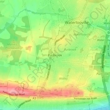
Navn: Topografisk kort Purbrook, højde, terræn.
Sted: Purbrook, Havant, Hampshire, England, PO7 5LN, United Kingdom (50.84791 -1.06408 50.88791 -1.02408)
Gennemsnitshøjde: 46 m
Minimum højde: 2 m
Maksimal højde: 103 m
Andre topografiske kort
Klik på et kort for at se dets topografi, dets højde og dets terræn.
Hayling Island
United Kingdom > England > Hampshire > Havant > North Hayling
An Iron Age shrine in the north of Hayling Island was later developed into a Roman temple in the 1st century BC and was first recorded in Richard Scott's Topographical and Historical Account of Hayling Island (1826). The site was dug between 1897 and 1907 and again from 1976 to 1978. The remains are now buried…
Gennemsnitshøjde: 1 m
Hayling Island
United Kingdom > England > Hampshire > Havant > Fleet
An Iron Age shrine in the north of Hayling Island was later developed into a Roman temple in the 1st century BC and was first recorded in Richard Scott's Topographical and Historical Account of Hayling Island (1826). The site was dug between 1897 and 1907 and again from 1976 to 1978. The remains are now buried…
Gennemsnitshøjde: 1 m