
Topografisk kort Gatton
Klik på kortet for at se højden.
Gatton
Gatton's elevations range from 215m AOD, the highest elevation, along Fort Lane, a cul-de-sac off the intersection of Reigate Hill (M25 Junction 8) which leads to four homes over the boundary in Reigate, a radio transmitter station, and a water tower. On the A217 is the Bridge House Hotel, whose name refers to a footbridge carrying the North Downs Way across the A217 85m to the east.
Om dette kort
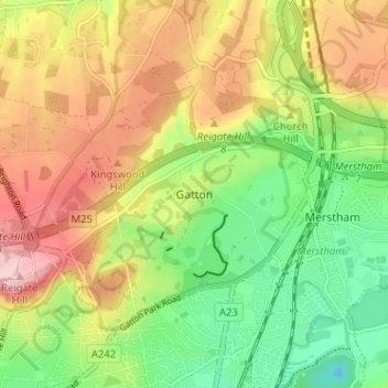
Navn: Topografisk kort Gatton, højde, terræn.
Gennemsnitshøjde: 134 m
Minimum højde: 46 m
Maksimal højde: 236 m
Andre topografiske kort
Klik på et kort for at se dets topografi, dets højde og dets terræn.
Lower Earlswood Lake
United Kingdom > England > Surrey > Reigate and Banstead > Redhill
Gennemsnitshøjde: 75 m
Redhill Common
United Kingdom > England > Surrey > Reigate and Banstead > Redhill
Gennemsnitshøjde: 92 m
Banstead Wood
United Kingdom > England > Surrey > Reigate and Banstead > Chipstead
Gennemsnitshøjde: 145 m
Reigate Park
United Kingdom > England > Surrey > Reigate and Banstead > Reigate
Gennemsnitshøjde: 80 m
Horley
United Kingdom > England > Surrey > Reigate and Banstead
Horley is at an altitude of around 54 m (177 ft) above mean sea level.
Gennemsnitshøjde: 58 m