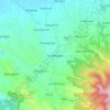
Topografisk kort Pemalang
Klik på kortet for at se højden.
Pemalang
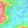
The regency has a varied topography. The northern part of the regency is a coastal area with an altitude ranging from 1 to 5 metres above sea level. The central part is a fertile lowland with an altitude of 6 to 15 metres above sea level; and the southern highlands and mountains are lush with cool air at an altitude varying from 16 to 925 metres above sea level. The region is crossed by two major rivers – the Waluh River and the Comal River. Most of the region is a fertile watershed.
Om dette kort

Navn: Topografisk kort Pemalang, højde, terræn.
Sted: Pemalang, Central Java, Java, Indonesia (-7.24889 109.18559 -6.77331 109.59920)
Gennemsnitshøjde: 295 m
Minimum højde: -1 m
Maksimal højde: 3.408 m
Andre topografiske kort
Klik på et kort for at se dets topografi, dets højde og dets terræn.










Ungaran
Indonesia > Central Java > Kabupaten Semarang
Ungaran (Dutch: Oengaran) is a town and adjacent areas in Central Java Province of Indonesia. The town serves as the administrative centre of the Semarang Regency in that province. Ungaran is located at -7° 8' 17", 110° 24' 18" at an elevation of 319 metres. It encompasses two districts (kecamatan) within…
Gennemsnitshøjde: 399 m





















Karimunjawa National Park
The geological formation in the archipelago is mostly dominated by quartz sandstone, gravel, mud, and clay. The topography of Karimunjawa Marine National Park is a wave of low land, with elevation ranging from 0–506 meters above sea level. Gajah hill is the Park’s highest point. Temperatures range from…
Gennemsnitshøjde: 1 m

Semarang
Semarang is located on the northern coast of Java. The city of Semarang is one of the important cities located on the north coast of Java and as the main hub connecting Jakarta and Surabaya, and cities in the southern interior of Java Surakarta and Yogyakarta. Semarang City has a height ranging from 2 m (6.6…
Gennemsnitshøjde: 88 m