
Giv en donation
Gør dig klar til dit næste eventyr:
Som Amazon-partner tjener denne side en kommission på kvalificerede køb uden ekstra omkostninger for dig.
Topografisk kort Mount Penanggungan
Klik på kortet for at se højden.
Giv en donation
Gør dig klar til dit næste eventyr:
Som Amazon-partner tjener denne side en kommission på kvalificerede køb uden ekstra omkostninger for dig.
Mount Penanggungan
There are sub-peaks around Penanggungan, starting to the southeast from Mount Wangi (Gunung Wangi) at 970 meters above sea level, Mount Bekel Jolotundo elevated 1,200 meters ASL, a semi-freestanding peak to the northwest; Puncak Kemuncup rising to 1,200 meters on the eastern face, Puncak Sarah Klopo on the southwestern slope elevated 1,250 meters, Puncak Awang-Awang located about 1,275 meters up the southwestern side, and Puncak Garuda Penanggungan south of the main peak topographing 1,520 meters. Bayangan Hill, located on the southern face at 1,250 meters up, is the main tourist attraction and a scenic spot. The peak is in Mojokerto Regency, with a portion of the slope in Prigen, Pasuruan Regency. As of 3 October 2024, Mt. Penanggungan has 1,213 Google Maps reviews with the quotient of stars to reviews noted to be 4.8.
Giv en donation
Gør dig klar til dit næste eventyr:
Som Amazon-partner tjener denne side en kommission på kvalificerede køb uden ekstra omkostninger for dig.
Om dette kort
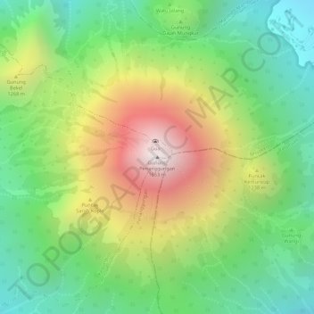
Navn: Topografisk kort Mount Penanggungan, højde, terræn.
Gennemsnitshøjde: 1.061 m
Minimum højde: 636 m
Maksimal højde: 1.639 m
Giv en donation
Gør dig klar til dit næste eventyr:
Som Amazon-partner tjener denne side en kommission på kvalificerede køb uden ekstra omkostninger for dig.