
Topografisk kort Bourne End
Klik på kortet for at se højden.
Om dette kort
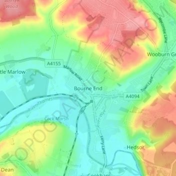
Navn: Topografisk kort Bourne End, højde, terræn.
Sted: Bourne End, Buckinghamshire, England, SL8 5ST, United Kingdom (51.55995 -0.73208 51.59995 -0.69208)
Gennemsnitshøjde: 57 m
Minimum højde: 19 m
Maksimal højde: 117 m
Andre topografiske kort
Klik på et kort for at se dets topografi, dets højde og dets terræn.
Chilterns National Landscape
United Kingdom > England > Buckinghamshire
The highest point is at 267 m (876 ft.) above sea level at Haddington Hill near Wendover in Buckinghamshire; a stone monument marks the summit. The nearby Ivinghoe Beacon is a more prominent hill, although its altitude is only 249 m (817 ft.). It is the starting point of the Icknield Way Path and the Ridgeway…
Gennemsnitshøjde: 102 m
Chiltern District
United Kingdom > England > Buckinghamshire > Buckland Common
Gennemsnitshøjde: 137 m
Aylesbury
United Kingdom > England > Buckinghamshire
Aylesbury is immediately southeast of the upper River Thame that flows past Thame to Dorchester on Thames and is partly sited on the two northernmost outcrops of Portland (lime)stone in England bisected by a small stream, Bear Brook which gives a relatively prominent position in relation to the terrain of all…
Gennemsnitshøjde: 85 m
Beaconsfield and Chepping Wye Community Board
United Kingdom > England > Buckinghamshire > Knotty Green
Gennemsnitshøjde: 115 m