
Giv en donation
Gør dig klar til dit næste eventyr:
Som Amazon-partner tjener denne side en kommission på kvalificerede køb uden ekstra omkostninger for dig.
Topografisk kort Bryce
Klik på kortet for at se højden.
Giv en donation
Gør dig klar til dit næste eventyr:
Som Amazon-partner tjener denne side en kommission på kvalificerede køb uden ekstra omkostninger for dig.
Om dette kort
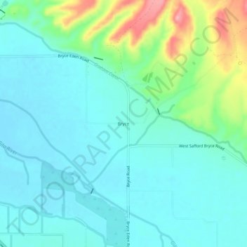
Navn: Topografisk kort Bryce, højde, terræn.
Sted: Bryce, Graham County, Arizona, 85543, United States (32.90895 -109.84786 32.94895 -109.80786)
Gennemsnitshøjde: 876 m
Minimum højde: 848 m
Maksimal højde: 972 m
Giv en donation
Gør dig klar til dit næste eventyr:
Som Amazon-partner tjener denne side en kommission på kvalificerede køb uden ekstra omkostninger for dig.
Andre topografiske kort
Klik på et kort for at se dets topografi, dets højde og dets terræn.
Safford
United States > Arizona > Graham County
The climate is cold semi-arid (Köppen: BSk) softened by the plateau rise (it receives enough rainfall not to fall into a cold desert, BWk). It is much hotter than most places in eastern Arizona due to its relatively low elevation of 2,953 feet (900 m) at the Agricultural Center where records are kept, and…
Gennemsnitshøjde: 912 m
Safford
United States > Arizona > Graham County
The climate is hot semi-arid (Köppen: BSh) softened by the plateau rise (it receives enough rainfall not to fall into a hot desert, BWh). It is much hotter than most places in eastern Arizona due to its relatively low elevation of 2,953 feet (900 m) at the Agricultural Center where records are kept, and often…
Gennemsnitshøjde: 911 m