
Giv en donation
Gør dig klar til dit næste eventyr:
Som Amazon-partner tjener denne side en kommission på kvalificerede køb uden ekstra omkostninger for dig.
Topografisk kort Nikoi Island
Klik på kortet for at se højden.
Giv en donation
Gør dig klar til dit næste eventyr:
Som Amazon-partner tjener denne side en kommission på kvalificerede køb uden ekstra omkostninger for dig.
Om dette kort
Navn: Topografisk kort Nikoi Island, højde, terræn.
Sted: Nikoi Island, Bintan, Riau Islands, Sumatra, Indonesia (0.73190 104.38959 1.37190 105.02959)
Gennemsnitshøjde: 3 m
Minimum højde: -4 m
Maksimal højde: 314 m
Giv en donation
Gør dig klar til dit næste eventyr:
Som Amazon-partner tjener denne side en kommission på kvalificerede køb uden ekstra omkostninger for dig.
Andre topografiske kort
Klik på et kort for at se dets topografi, dets højde og dets terræn.
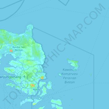
Bintan Island
Indonesia > Riau Islands > Bintan
Bintan, is the largest among the 3,200 islands of Riau Archipelago and is located 10 kilometres (6.2 mi) east of the Batam Island. It has a coast line of 105 kilometres (65 mi) and has rolling topography in its landform. The Riau Islands are a province of Indonesia, which encompassed the Riau Archipelago,…
Gennemsnitshøjde: 6 m