Geolocate

Topografisk kort Ashford

Klik på kortet for at se højden.

Om dette kort

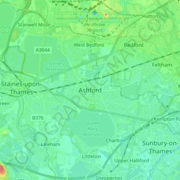
Navn: Topografisk kort Ashford, højde, terræn.

Sted: Ashford, Borough of Spelthorne, Surrey, England, TW15 2TS, United Kingdom (51.39302 -0.50198 51.47302 -0.42198)

Gennemsnitshøjde: 17 m

Minimum højde: 3 m

Maksimal højde: 67 m

Andre topografiske kort

Klik på et kort for at se dets topografi, dets højde og dets terræn.

Shepperton

United Kingdom > England > Surrey > Borough of Spelthorne

Shepperton has a long boundary with the River Thames in its southernmost salient, which almost surrounds Spelthorne. Old Shepperton is almost surrounded by the extreme southern meander within this. Prehistoric glacial retreat north of this has made the north bank almost flat for a considerable distance and as…

Gennemsnitshøjde: 12 m

Gør dig klar til dit næste eventyr:

🚶Fodcreme til vandrere - Pleje til trætte fødder efter en lang dag
🪓Multiværktøj til outdoor - Kombineret værktøj til telt, reb og nødbrug
🚲Cykeltasker til tur - Tasker til cykelrejsen
📯Nødfløjte - Lille men kraftig fløjte til nødsituationer
📖Overlevelsesguide - Lær nyttige færdigheder til livet i naturen

Som Amazon-partner tjener denne side en kommission på kvalificerede køb uden ekstra omkostninger for dig.