
Giv en donation
Gør dig klar til dit næste eventyr:
Som Amazon-partner tjener denne side en kommission på kvalificerede køb uden ekstra omkostninger for dig.
Topografisk kort Ardez
Klik på kortet for at se højden.
Giv en donation
Gør dig klar til dit næste eventyr:
Som Amazon-partner tjener denne side en kommission på kvalificerede køb uden ekstra omkostninger for dig.
Om dette kort
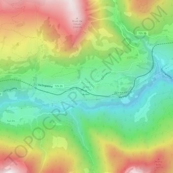
Navn: Topografisk kort Ardez, højde, terræn.
Gennemsnitshøjde: 1.699 m
Minimum højde: 1.241 m
Maksimal højde: 2.363 m
Giv en donation
Gør dig klar til dit næste eventyr:
Som Amazon-partner tjener denne side en kommission på kvalificerede køb uden ekstra omkostninger for dig.
Andre topografiske kort
Klik på et kort for at se dets topografi, dets højde og dets terræn.
Scuol
Switzerland > Grisons > Region Engiadina Bassa/Val Müstair
The God da Tamangur ("the forest back there") is the highest continuous stone pine (pinus cembra) forest in Europe, right at the furthest end of the Val S-charl, south of Scuol. The forest nature reserve covers an area of about 84 ha (210 acres) at up to 2,400 m (7,900 ft) in elevation. Due to the altitude and…
Gennemsnitshøjde: 2.240 m
Zernez
Switzerland > Grisons > Region Engiadina Bassa/Val Müstair
Lai da Ova Spin is a compensation reservoir on the river Spöl. It is located in the upper areas of the Lower Engadine valley (Romansh: Engiadina Bassa). It is located at an elevation of 1,473 m (4,833 ft) and is connected to the railway network of the Rhätische Bahn. In Zernez, the stream Spöl empties into…
Gennemsnitshøjde: 2.297 m
Swiss National Park
Switzerland > Grisons > Region Engiadina Bassa/Val Müstair
Gennemsnitshøjde: 2.283 m