
Giv en donation
Gør dig klar til dit næste eventyr:
Som Amazon-partner tjener denne side en kommission på kvalificerede køb uden ekstra omkostninger for dig.
Topografisk kort Broadstairs
Klik på kortet for at se højden.
Giv en donation
Gør dig klar til dit næste eventyr:
Som Amazon-partner tjener denne side en kommission på kvalificerede køb uden ekstra omkostninger for dig.
Om dette kort
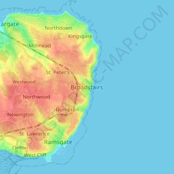
Navn: Topografisk kort Broadstairs, højde, terræn.
Sted: Broadstairs, Thanet, Kent, England, CT10 1BH, United Kingdom (51.31868 1.40079 51.39868 1.48079)
Gennemsnitshøjde: 14 m
Minimum højde: 0 m
Maksimal højde: 57 m
Giv en donation
Gør dig klar til dit næste eventyr:
Som Amazon-partner tjener denne side en kommission på kvalificerede køb uden ekstra omkostninger for dig.
Andre topografiske kort
Klik på et kort for at se dets topografi, dets højde og dets terræn.
Ramsgate
United Kingdom > England > Kent > Thanet
In 2017 Ramsgate was chosen as one of the first ten Heritage Action Zones (HAZ) by Historic England, with the aim of stimulating economic growth by taking advantage of Ramsgate's historic environment. Part of this project included a Historic Landscape Characterisation Study which assessed and mapped the…
Gennemsnitshøjde: 25 m
Giv en donation
Gør dig klar til dit næste eventyr:
Som Amazon-partner tjener denne side en kommission på kvalificerede køb uden ekstra omkostninger for dig.
Ramsgate
United Kingdom > England > Kent > Thanet
In 2017 Ramsgate was chosen as one of the first ten Heritage Action Zones (HAZ) by Historic England, with the aim of stimulating economic growth using Ramsgate's historic environment as a catalyst. Part of this project included a Historic Landscape Characterisation Study which assessed and mapped the patterns…
Gennemsnitshøjde: 25 m