
Giv en donation
Gør dig klar til dit næste eventyr:
Som Amazon-partner tjener denne side en kommission på kvalificerede køb uden ekstra omkostninger for dig.
Topografisk kort Quorn
Klik på kortet for at se højden.
Giv en donation
Gør dig klar til dit næste eventyr:
Som Amazon-partner tjener denne side en kommission på kvalificerede køb uden ekstra omkostninger for dig.
Om dette kort
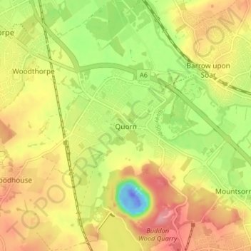
Navn: Topografisk kort Quorn, højde, terræn.
Gennemsnitshøjde: 55 m
Minimum højde: -59 m
Maksimal højde: 102 m
Giv en donation
Gør dig klar til dit næste eventyr:
Som Amazon-partner tjener denne side en kommission på kvalificerede køb uden ekstra omkostninger for dig.
Andre topografiske kort
Klik på et kort for at se dets topografi, dets højde og dets terræn.
Watermead Country Park
United Kingdom > England > Leicestershire > Charnwood > Birstall
Gennemsnitshøjde: 59 m
South Croxton
United Kingdom > England > Leicestershire > Charnwood > South Croxton
The highest point is the church, at 120 m above mean sea level. The lowest altitude is 85 m by the Queniborough Brook.
Gennemsnitshøjde: 108 m
Giv en donation
Gør dig klar til dit næste eventyr:
Som Amazon-partner tjener denne side en kommission på kvalificerede køb uden ekstra omkostninger for dig.
Queniborough
United Kingdom > England > Leicestershire > Charnwood > Queniborough
Gennemsnitshøjde: 75 m
Barrow upon Soar
United Kingdom > England > Leicestershire > Charnwood > Barrow upon Soar
Gennemsnitshøjde: 62 m
Bradgate Park
United Kingdom > England > Leicestershire > Charnwood > Newtown Linford
Overlying the Beacon Hill Formation, but found a little further down the hillside to the south, are the Bradgate Formation beds, the most notable of which is the Sliding Stone Slump Breccia rocks. Forming a line of crags below Old John, these are laminated mudstones, with layers of sandstone, mainly of…
Gennemsnitshøjde: 126 m
Giv en donation
Gør dig klar til dit næste eventyr:
Som Amazon-partner tjener denne side en kommission på kvalificerede køb uden ekstra omkostninger for dig.
Top Town Plantation
United Kingdom > England > Leicestershire > Charnwood > Walton on the Wolds
Gennemsnitshøjde: 85 m
Mountsorrel
United Kingdom > England > Leicestershire > Charnwood > Mountsorrel
Gennemsnitshøjde: 57 m
Giv en donation
Gør dig klar til dit næste eventyr:
Som Amazon-partner tjener denne side en kommission på kvalificerede køb uden ekstra omkostninger for dig.
Moat Hill Spinney
United Kingdom > England > Leicestershire > Charnwood > Cotes
Gennemsnitshøjde: 50 m
Lea Wood
United Kingdom > England > Leicestershire > Charnwood > Newtown Linford
Gennemsnitshøjde: 170 m
Charnwood Water
United Kingdom > England > Leicestershire > Charnwood > Woodthorpe
Gennemsnitshøjde: 47 m
Giv en donation
Gør dig klar til dit næste eventyr:
Som Amazon-partner tjener denne side en kommission på kvalificerede køb uden ekstra omkostninger for dig.
Giv en donation
Gør dig klar til dit næste eventyr:
Som Amazon-partner tjener denne side en kommission på kvalificerede køb uden ekstra omkostninger for dig.
Giv en donation
Gør dig klar til dit næste eventyr:
Som Amazon-partner tjener denne side en kommission på kvalificerede køb uden ekstra omkostninger for dig.
East Goscote
United Kingdom > England > Leicestershire > Charnwood > East Goscote
Gennemsnitshøjde: 61 m
Swithland Wood
United Kingdom > England > Leicestershire > Charnwood > Swithland
Gennemsnitshøjde: 107 m
Giv en donation
Gør dig klar til dit næste eventyr:
Som Amazon-partner tjener denne side en kommission på kvalificerede køb uden ekstra omkostninger for dig.
Beacon Hill Country Park
United Kingdom > England > Leicestershire > Charnwood > Woodhouse Eaves
Gennemsnitshøjde: 164 m
Beeby
United Kingdom > England > Leicestershire > Charnwood
The physical and historical development of the hamlet has been strongly influenced by the local topography and its relative isolation. Beeby is situated within an established agricultural landscape largely in pastoral use. Until 1904 the east-west route was the only route through the hamlet, which was referred…
Gennemsnitshøjde: 101 m
Giv en donation
Gør dig klar til dit næste eventyr:
Som Amazon-partner tjener denne side en kommission på kvalificerede køb uden ekstra omkostninger for dig.
Barrow upon Soar
United Kingdom > England > Leicestershire > Charnwood > Barrow upon Soar
Gennemsnitshøjde: 62 m
Giv en donation
Gør dig klar til dit næste eventyr:
Som Amazon-partner tjener denne side en kommission på kvalificerede køb uden ekstra omkostninger for dig.
Mammoth Lake
United Kingdom > England > Leicestershire > Charnwood > Thurmaston
Gennemsnitshøjde: 58 m
Giv en donation
Gør dig klar til dit næste eventyr:
Som Amazon-partner tjener denne side en kommission på kvalificerede køb uden ekstra omkostninger for dig.