
Giv en donation
Gør dig klar til dit næste eventyr:
Som Amazon-partner tjener denne side en kommission på kvalificerede køb uden ekstra omkostninger for dig.
Topografisk kort Wolf Lake
Klik på kortet for at se højden.
Giv en donation
Gør dig klar til dit næste eventyr:
Som Amazon-partner tjener denne side en kommission på kvalificerede køb uden ekstra omkostninger for dig.
Om dette kort
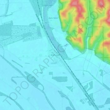
Navn: Topografisk kort Wolf Lake, højde, terræn.
Sted: Wolf Lake, Union County, Illinois, 62998, United States (37.48422 -89.45843 37.52422 -89.41843)
Gennemsnitshøjde: 117 m
Minimum højde: 101 m
Maksimal højde: 208 m
Giv en donation
Gør dig klar til dit næste eventyr:
Som Amazon-partner tjener denne side en kommission på kvalificerede køb uden ekstra omkostninger for dig.
Andre topografiske kort
Klik på et kort for at se dets topografi, dets højde og dets terræn.
Anna
United States > Illinois > Union County
The coming of the railroad can be credited for prompting the founding of the City of Anna, although, from the time of the George Rogers Clark expedition into Southern Illinois country, emigrants recognized its agricultural possibilities. Centrally located in Anna Precinct of Union County, Anna was established…
Gennemsnitshøjde: 183 m