
Giv en donation
Gør dig klar til dit næste eventyr:
Som Amazon-partner tjener denne side en kommission på kvalificerede køb uden ekstra omkostninger for dig.
Topografisk kort Herrenschwanden
Klik på kortet for at se højden.
Giv en donation
Gør dig klar til dit næste eventyr:
Som Amazon-partner tjener denne side en kommission på kvalificerede køb uden ekstra omkostninger for dig.
Om dette kort
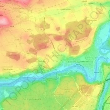
Navn: Topografisk kort Herrenschwanden, højde, terræn.
Gennemsnitshøjde: 560 m
Minimum højde: 482 m
Maksimal højde: 637 m
Giv en donation
Gør dig klar til dit næste eventyr:
Som Amazon-partner tjener denne side en kommission på kvalificerede køb uden ekstra omkostninger for dig.
Andre topografiske kort
Klik på et kort for at se dets topografi, dets højde og dets terræn.
Bern
Switzerland > Bern > Bern-Mittelland administrative district
Bern is built on very uneven ground. An elevation difference of up to 60 metres exists between the inner city districts on the Aare (Matte, Marzili) and the higher ones (Kirchenfeld, Länggasse).
Gennemsnitshøjde: 612 m
Bern
Switzerland > Bern > Bern-Mittelland administrative district
Bern is built on very uneven ground. An elevation difference of up to 60 metres exists between the inner city districts on the Aare (Matte, Marzili) and the higher ones (Kirchenfeld, Länggasse).
Gennemsnitshøjde: 612 m
Bern
Switzerland > Bern > Bern-Mittelland administrative district
Bern is built on very uneven ground. An elevation difference of up to 60 metres exists between the inner city districts on the Aare (Matte, Marzili) and the higher ones (Kirchenfeld, Länggasse).
Gennemsnitshøjde: 612 m
Niederwangen
Switzerland > Bern > Bern-Mittelland administrative district > Köniz
Gennemsnitshøjde: 626 m
Giv en donation
Gør dig klar til dit næste eventyr:
Som Amazon-partner tjener denne side en kommission på kvalificerede køb uden ekstra omkostninger for dig.
Schloss Wittigkofen
Switzerland > Bern > Bern-Mittelland administrative district > Bern > Schloss Wittigkofen
Gennemsnitshøjde: 568 m
Giv en donation
Gør dig klar til dit næste eventyr:
Som Amazon-partner tjener denne side en kommission på kvalificerede køb uden ekstra omkostninger for dig.
Bern
Switzerland > Bern > Bern-Mittelland administrative district
Bern is built on very uneven ground. An elevation difference of up to 60 metres exists between the inner city districts on the Aare (Matte, Marzili) and the higher ones (Kirchenfeld, Länggasse).
Gennemsnitshøjde: 612 m
Bern
Switzerland > Bern > Bern-Mittelland administrative district
Bern is built on very uneven ground. An elevation difference of up to 60 metres exists between the inner city districts on the Aare (Matte, Marzili) and the higher ones (Kirchenfeld, Länggasse).
Gennemsnitshøjde: 612 m
Bern
Switzerland > Bern > Bern-Mittelland administrative district
Bern is built on very uneven ground. An elevation difference of up to 60 metres exists between the inner city districts on the Aare (Matte, Marzili) and the higher ones (Kirchenfeld, Länggasse).
Gennemsnitshøjde: 612 m
Giv en donation
Gør dig klar til dit næste eventyr:
Som Amazon-partner tjener denne side en kommission på kvalificerede køb uden ekstra omkostninger for dig.
Niederwangen
Switzerland > Bern > Bern-Mittelland administrative district > Köniz
Gennemsnitshøjde: 627 m
Giv en donation
Gør dig klar til dit næste eventyr:
Som Amazon-partner tjener denne side en kommission på kvalificerede køb uden ekstra omkostninger for dig.
Konolfingen
Switzerland > Bern > Bern-Mittelland administrative district
Lying at an altitude of over 650 meters (2,130 ft), Konolfingen is often referred to as the "gateway to the Emmental."
Gennemsnitshøjde: 745 m
Bern
Switzerland > Bern > Bern-Mittelland administrative district
Bern is built on very uneven ground. An elevation difference of up to 60 metres exists between the inner city districts on the Aare (Matte, Marzili) and the higher ones (Kirchenfeld, Länggasse).
Gennemsnitshøjde: 612 m
Thörishaus
Switzerland > Bern > Bern-Mittelland administrative district > Köniz
Gennemsnitshøjde: 653 m
Giv en donation
Gør dig klar til dit næste eventyr:
Som Amazon-partner tjener denne side en kommission på kvalificerede køb uden ekstra omkostninger for dig.
Bremgarten bei Bern
Switzerland > Bern > Bern-Mittelland administrative district
Gennemsnitshøjde: 540 m
Oberthal
Switzerland > Bern > Bern-Mittelland administrative district > Oberthal
Gennemsnitshøjde: 870 m
Ittigen
Switzerland > Bern > Bern-Mittelland administrative district
The municipality is located in the Worblental (Worblen valley) on a terrace on the Mannenberg (elevation 688 m [2,257 ft]) in the agglomeration of Bern.
Gennemsnitshøjde: 595 m
Giv en donation
Gør dig klar til dit næste eventyr:
Som Amazon-partner tjener denne side en kommission på kvalificerede køb uden ekstra omkostninger for dig.