
Giv en donation
Gør dig klar til dit næste eventyr:
Som Amazon-partner tjener denne side en kommission på kvalificerede køb uden ekstra omkostninger for dig.
Topografisk kort Great Houghton
Klik på kortet for at se højden.
Giv en donation
Gør dig klar til dit næste eventyr:
Som Amazon-partner tjener denne side en kommission på kvalificerede køb uden ekstra omkostninger for dig.
Great Houghton
Great Houghton is a village and civil parish in the Metropolitan Borough of Barnsley in South Yorkshire, England), on the border with West Yorkshire. It lies to the west of Thurnscoe, on the B6411 road, and is located at approximately 53° 33' 20" north, 1° 21' west, at an elevation of around 60 m above sea level. At the 2001 census it had a population of 2,261, increasing to 2,475 at the 2011 census.
Giv en donation
Gør dig klar til dit næste eventyr:
Som Amazon-partner tjener denne side en kommission på kvalificerede køb uden ekstra omkostninger for dig.
Om dette kort
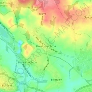
Navn: Topografisk kort Great Houghton, højde, terræn.
Gennemsnitshøjde: 54 m
Minimum højde: 13 m
Maksimal højde: 112 m
Giv en donation
Gør dig klar til dit næste eventyr:
Som Amazon-partner tjener denne side en kommission på kvalificerede køb uden ekstra omkostninger for dig.