
Tak fordi du støtter denne side ❤️
Giv en donation
Giv en donation
Gør dig klar til dit næste eventyr:
Som Amazon-partner tjener denne side en kommission på kvalificerede køb uden ekstra omkostninger for dig.
Topografisk kort Ka
Klik på kortet for at se højden.
Tak fordi du støtter denne side ❤️
Giv en donation
Giv en donation
Gør dig klar til dit næste eventyr:
Som Amazon-partner tjener denne side en kommission på kvalificerede køb uden ekstra omkostninger for dig.
Om dette kort
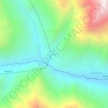
Navn: Topografisk kort Ka, højde, terræn.
Sted: Ka, Spiti, Lahaul and Spiti District, Himachal Pradesh, Indien (32.02716 78.00381 32.06716 78.04381)
Gennemsnitshøjde: 4.127 m
Minimum højde: 3.619 m
Maksimal højde: 5.294 m
Tak fordi du støtter denne side ❤️
Giv en donation
Giv en donation
Gør dig klar til dit næste eventyr:
Som Amazon-partner tjener denne side en kommission på kvalificerede køb uden ekstra omkostninger for dig.