
Giv en donation
Gør dig klar til dit næste eventyr:
Som Amazon-partner tjener denne side en kommission på kvalificerede køb uden ekstra omkostninger for dig.
Topografisk kort Arcosanti
Klik på kortet for at se højden.
Giv en donation
Gør dig klar til dit næste eventyr:
Som Amazon-partner tjener denne side en kommission på kvalificerede køb uden ekstra omkostninger for dig.
Arcosanti
Arcosanti is a projected experimental town with a bronze bell casting business in Yavapai County, central Arizona, United States, 70 mi (110 km) north of Phoenix, at an elevation of 3,732 feet (1,138 m). Its arcology concept was proposed by Italian-American architect Paolo Soleri (1919–2013). He began construction in 1970 to demonstrate how urban conditions could be improved while minimizing the destructive impact on the Earth. He taught and influenced generations of architects and urban designers who studied and worked with him there to build the proposed town.
Giv en donation
Gør dig klar til dit næste eventyr:
Som Amazon-partner tjener denne side en kommission på kvalificerede køb uden ekstra omkostninger for dig.
Om dette kort
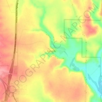
Navn: Topografisk kort Arcosanti, højde, terræn.
Sted: Arcosanti, Yavapai County, Arizona, United States (34.32278 -112.12063 34.36278 -112.08063)
Gennemsnitshøjde: 1.130 m
Minimum højde: 1.067 m
Maksimal højde: 1.173 m
Giv en donation
Gør dig klar til dit næste eventyr:
Som Amazon-partner tjener denne side en kommission på kvalificerede køb uden ekstra omkostninger for dig.
Andre topografiske kort
Klik på et kort for at se dets topografi, dets højde og dets terræn.
Lynx Lake
United States > Arizona > Yavapai County
Lynx Lake, Arizona, is a 55-acre (220,000 m2) reservoir located within Prescott National Forest, approximately 5 miles (8.0 km) east of Prescott, Arizona, in the Bradshaw Mountains. The lake is located at 5,530 feet (1,690 m) elevation and is stocked for fishing. It is one of the most popular recreation areas…
Gennemsnitshøjde: 1.726 m
Chino Valley
United States > Arizona > Yavapai County
The town is in north-central Arizona, on state Highway 89, 15 miles (24 km) north of Prescott and 35 miles (56 km) south of Ash Fork, which is on Interstate 40. Chino Valley is at an elevation of about 4,750 feet (1,450 m).
Gennemsnitshøjde: 1.454 m
Giv en donation
Gør dig klar til dit næste eventyr:
Som Amazon-partner tjener denne side en kommission på kvalificerede køb uden ekstra omkostninger for dig.
Giv en donation
Gør dig klar til dit næste eventyr:
Som Amazon-partner tjener denne side en kommission på kvalificerede køb uden ekstra omkostninger for dig.
Seligman
United States > Arizona > Yavapai County
Seligman is located at 35°19′42″N 112°52′27″W / 35.32833°N 112.87417°W / 35.32833; -112.87417 (35.328199, −112.874303), at 5,240 feet (1,600 m) in elevation, alongside the Big Chino Wash, in a northern section of Chino Valley. The wash is a major tributary of the Verde River. Seligman is…
Gennemsnitshøjde: 1.617 m
Cedar Bench Wilderness
United States > Arizona > Yavapai County
Cedar Bench Wilderness is a protected wilderness area in the Prescott National Forest in the U.S. state of Arizona. Established in 1984 under the Arizona Wilderness Act, the area protects the large "bench" that divides the Agua Fria and Verde River drainages. Elevations range from 4,500 feet (1,371 m) to 6,700…
Gennemsnitshøjde: 1.349 m
Giv en donation
Gør dig klar til dit næste eventyr:
Som Amazon-partner tjener denne side en kommission på kvalificerede køb uden ekstra omkostninger for dig.