
Topografisk kort Mengham
Klik på kortet for at se højden.
Om dette kort
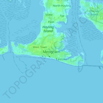
Navn: Topografisk kort Mengham, højde, terræn.
Sted: Mengham, Havant, Hampshire, England, PO11 9BG, United Kingdom (50.74792 -1.01588 50.82792 -0.93588)
Gennemsnitshøjde: 1 m
Minimum højde: -3 m
Maksimal højde: 10 m
Andre topografiske kort
Klik på et kort for at se dets topografi, dets højde og dets terræn.
Rowlands Castle
United Kingdom > England > Hampshire > East Hampshire > Finchdean
Gennemsnitshøjde: 72 m
Basingstoke
United Kingdom > England > Hampshire > Basingstoke and Deane
Situated in a valley through the Hampshire Downs at an average elevation of 88 metres (289 ft) Basingstoke is a major interchange between Reading, Newbury, Andover, Winchester, and Alton, and lies on the natural trade route between the southwest of England and London. The area had been something of an…
Gennemsnitshøjde: 109 m
Medstead
United Kingdom > England > Hampshire > East Hampshire
Medstead is a village and civil parish in the East Hampshire district of Hampshire, England. Its nearest town is Alton, which lies 4.3 miles (6.9 km) northeast of the village. According to the 2011 census, the village had a population of 2,036 people. The parish covers an area of 1,536 acres (622 ha) and has…
Gennemsnitshøjde: 186 m
Winterhill Plantation
United Kingdom > England > Hampshire > Basingstoke and Deane > Whitchurch > Wells-In-The-Field
Gennemsnitshøjde: 100 m
Hayling Island
United Kingdom > England > Hampshire > Havant > North Hayling
An Iron Age shrine in the north of Hayling Island was later developed into a Roman temple in the 1st century BC and was first recorded in Richard Scott's Topographical and Historical Account of Hayling Island (1826). The site was dug between 1897 and 1907 and again from 1976 to 1978. The remains are now buried…
Gennemsnitshøjde: 1 m
Rowland's Copse, Red Hill
United Kingdom > England > Hampshire > East Hampshire > Rowlands Castle
Gennemsnitshøjde: 42 m
Morgaston Wood
United Kingdom > England > Hampshire > Basingstoke and Deane > Sherborne St John
Gennemsnitshøjde: 76 m
Newton Valence
United Kingdom > England > Hampshire > East Hampshire
The village sits high in the westernmost chalk hills of the South Downs: maximum elevation 191 metres (627 feet) above sea level. Much of the surrounding landscape is within the East Hampshire Area of Outstanding Natural Beauty.
Gennemsnitshøjde: 153 m
Bath Meadows
United Kingdom > England > Hampshire > Test Valley > Wellow > East Wellow
Gennemsnitshøjde: 30 m
Mortimer West End
United Kingdom > England > Hampshire > Basingstoke and Deane > Mortimer West End
Gennemsnitshøjde: 90 m
Wootton St. Lawrence
United Kingdom > England > Hampshire > Basingstoke and Deane
Gennemsnitshøjde: 115 m