
Giv en donation
Gør dig klar til dit næste eventyr:
Som Amazon-partner tjener denne side en kommission på kvalificerede køb uden ekstra omkostninger for dig.
Topografisk kort Mitlödi
Klik på kortet for at se højden.
Giv en donation
Gør dig klar til dit næste eventyr:
Som Amazon-partner tjener denne side en kommission på kvalificerede køb uden ekstra omkostninger for dig.
Mitlödi
Mitlödi is located in the valley of the Linth river, on a pre-historic rock slide, at an elevation of 504 m (1,654 ft). It consists of the village of Mitlödi itself, and the separate section of Ennetlinth on the right bank of the Linth. The village of Schwanden lies upstream and to the south, whilst the town of Glarus is downstream and to the north.
Giv en donation
Gør dig klar til dit næste eventyr:
Som Amazon-partner tjener denne side en kommission på kvalificerede køb uden ekstra omkostninger for dig.
Om dette kort
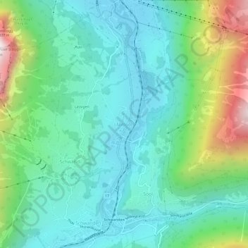
Navn: Topografisk kort Mitlödi, højde, terræn.
Sted: Mitlödi, Glarus Süd, Glarus, 8756, Switzerland (46.99147 9.05991 47.03147 9.09991)
Gennemsnitshøjde: 800 m
Minimum højde: 481 m
Maksimal højde: 1.745 m
Giv en donation
Gør dig klar til dit næste eventyr:
Som Amazon-partner tjener denne side en kommission på kvalificerede køb uden ekstra omkostninger for dig.