
Giv en donation
Gør dig klar til dit næste eventyr:
Som Amazon-partner tjener denne side en kommission på kvalificerede køb uden ekstra omkostninger for dig.
Topografisk kort Crystal Beach
Klik på kortet for at se højden.
Giv en donation
Gør dig klar til dit næste eventyr:
Som Amazon-partner tjener denne side en kommission på kvalificerede køb uden ekstra omkostninger for dig.
Om dette kort
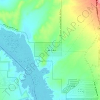
Navn: Topografisk kort Crystal Beach, højde, terræn.
Gennemsnitshøjde: 172 m
Minimum højde: 136 m
Maksimal højde: 264 m
Giv en donation
Gør dig klar til dit næste eventyr:
Som Amazon-partner tjener denne side en kommission på kvalificerede køb uden ekstra omkostninger for dig.
Andre topografiske kort
Klik på et kort for at se dets topografi, dets højde og dets terræn.
Hoover Dam
United States > Arizona > Mohave County
The amount of electricity generated by Hoover Dam has been decreasing along with the falling water level in Lake Mead due to the prolonged drought since year 2000 and high demand for the Colorado River's water. By 2014 its generating capacity was downrated by 23% to 1592 MW and was providing power only during…
Gennemsnitshøjde: 429 m
Bullhead City
United States > Arizona > Mohave County
Hardyville Pioneer Cemetery, a small cemetery, now a historic landmark at 35°7′16″N 114°35′17″W / 35.12111°N 114.58806°W / 35.12111; -114.58806, is the most significant existing remnant of Hardyville. An unofficial historical marker for the town is in the parking lot across Highway 95 from…
Gennemsnitshøjde: 328 m
Giv en donation
Gør dig klar til dit næste eventyr:
Som Amazon-partner tjener denne side en kommission på kvalificerede køb uden ekstra omkostninger for dig.
Antares
United States > Arizona > Mohave County > Antares
Antares is located in northwestern Arizona, in central Mohave County, 21 miles (34 km) northeast of Kingman, the county seat. The Antares census-designated place encompasses 0.65 square miles (1.7 km2) of land, and is at 3,556 feet (1,084 m) elevation above sea level. The southern edge of the CDP follows State…
Gennemsnitshøjde: 1.060 m
Giv en donation
Gør dig klar til dit næste eventyr:
Som Amazon-partner tjener denne side en kommission på kvalificerede køb uden ekstra omkostninger for dig.
Kingman
United States > Arizona > Mohave County
Lt. Edward Fitzgerald Beale, a U.S. Navy officer in the service of the Army Corps of Topographical Engineers, was ordered by the U.S. War Department to build a federal wagon road across the 35th parallel. His secondary orders were to test the feasibility of the use of camels as pack animals in the Southwestern…
Gennemsnitshøjde: 1.131 m
Hoover Dam
United States > Arizona > Mohave County
The amount of electricity generated by Hoover Dam has been decreasing along with the falling water level in Lake Mead due to the prolonged drought since year 2000 and high demand for the Colorado River's water. By 2014 its generating capacity was downrated by 23% to 1592 MW and was providing power only during…
Gennemsnitshøjde: 429 m
Giv en donation
Gør dig klar til dit næste eventyr:
Som Amazon-partner tjener denne side en kommission på kvalificerede køb uden ekstra omkostninger for dig.
Hoover Dam
United States > Arizona > Mohave County
The amount of electricity generated by Hoover Dam has been decreasing along with the falling water level in Lake Mead due to the prolonged drought in the 2010s and high demand for the Colorado River's water. Lake Mead fell to a new record low elevation of 1,071.61 feet (326.63 m) on July 1, 2016 before…
Gennemsnitshøjde: 429 m
Bullhead City
United States > Arizona > Mohave County
Hardyville Pioneer Cemetery, a small cemetery, now a historic landmark at 35°7′16″N 114°35′17″W / 35.12111°N 114.58806°W / 35.12111; -114.58806, is the most significant existing remnant of Hardyville. An unofficial historical marker for the town is in the parking lot across Highway 95 from…
Gennemsnitshøjde: 322 m
Giv en donation
Gør dig klar til dit næste eventyr:
Som Amazon-partner tjener denne side en kommission på kvalificerede køb uden ekstra omkostninger for dig.
Bullhead City
United States > Arizona > Mohave County
Hardyville Pioneer Cemetery, a small cemetery, now a historic landmark at 35°7′16″N 114°35′17″W / 35.12111°N 114.58806°W / 35.12111; -114.58806, is the most significant existing remnant of Hardyville. An unofficial historical marker for the town is in the parking lot across Highway 95 from…
Gennemsnitshøjde: 328 m
Kingman
United States > Arizona > Mohave County
Lt. Edward Fitzgerald Beale, a U.S. Navy officer in the service of the Army Corps of Topographical Engineers, was ordered by the U.S. War Department to build a federal wagon road across the 35th parallel. His secondary orders were to test the feasibility of the use of camels as pack animals in the Southwestern…
Gennemsnitshøjde: 1.130 m
Giv en donation
Gør dig klar til dit næste eventyr:
Som Amazon-partner tjener denne side en kommission på kvalificerede køb uden ekstra omkostninger for dig.
Kingman
United States > Arizona > Mohave County > Kingman
Lt. Edward Fitzgerald Beale, a U.S. Navy officer in the service of the U.S. Army Corps of Topographical Engineers, was ordered by the U.S. War Department to build a federal wagon road across the 35th Parallel. His secondary orders were to test the feasibility of the use of camels as pack animals in the…
Gennemsnitshøjde: 1.135 m
Giv en donation
Gør dig klar til dit næste eventyr:
Som Amazon-partner tjener denne side en kommission på kvalificerede køb uden ekstra omkostninger for dig.