
Giv en donation
Gør dig klar til dit næste eventyr:
Som Amazon-partner tjener denne side en kommission på kvalificerede køb uden ekstra omkostninger for dig.
Topografisk kort Shanghai
Klik på kortet for at se højden.
Giv en donation
Gør dig klar til dit næste eventyr:
Som Amazon-partner tjener denne side en kommission på kvalificerede køb uden ekstra omkostninger for dig.
Shanghai
The golden age of Shanghai began with its elevation to municipality after it was separated from Jiangsu on 7 July 1927. This new Chinese municipality covered an area of 494.69 km2 (191.0 sq mi), including the modern-day districts of Baoshan, Yangpu, Zhabei, Nanshi, and Pudong, but excluded the foreign concessions territories. Headed by a Chinese mayor and municipal council, the new city government's first task—the Greater Shanghai Plan—was to create a new city center in Jiangwan town of Yangpu district, outside the boundaries of the foreign concessions. The plan included a public museum, library, sports stadium, and city hall, which were partially constructed before being interrupted by the Japanese invasion.
Giv en donation
Gør dig klar til dit næste eventyr:
Som Amazon-partner tjener denne side en kommission på kvalificerede køb uden ekstra omkostninger for dig.
Om dette kort
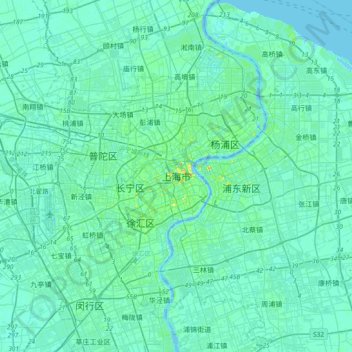
Navn: Topografisk kort Shanghai, højde, terræn.
Sted: Shanghai, Huangpu District, Shanghai, 200001, China (31.07228 121.30921 31.39228 121.62921)
Gennemsnitshøjde: 5 m
Minimum højde: -5 m
Maksimal højde: 42 m
Giv en donation
Gør dig klar til dit næste eventyr:
Som Amazon-partner tjener denne side en kommission på kvalificerede køb uden ekstra omkostninger for dig.