
Topografisk kort Shafton Two Gates
Klik på kortet for at se højden.
Shafton Two Gates
Shafton lies to the north of Shafton Two Gates, on the road to Ryhill. It is located at approximately 53° 35' 10" North, 1° 24' West, at an elevation of around 262 feet (80 m) above sea level. Sceptun in the Domesday Book of 1086 then later in c. 1160 Scaftona meaning a farmstead marked by a pole, or made with poles.
Om dette kort
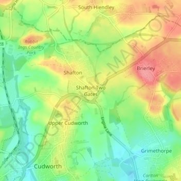
Navn: Topografisk kort Shafton Two Gates, højde, terræn.
Gennemsnitshøjde: 68 m
Minimum højde: 34 m
Maksimal højde: 111 m
Andre topografiske kort
Klik på et kort for at se dets topografi, dets højde og dets terræn.
Shafton
United Kingdom > England > Barnsley
Shafton lies to the north of Shafton Two Gates, on the road to Ryhill. It is located at approximately 53° 35' 10" North, 1° 24' West, at an elevation of around 262 feet (80 m) above sea level. Sceptun in the Domesday Book of 1086 then later in c. 1160 Scaftona meaning a farmstead marked by a pole, or made…
Gennemsnitshøjde: 65 m
High Hoyland
United Kingdom > England > Barnsley
High Hoyland is a village and civil parish in the Metropolitan Borough of Barnsley in South Yorkshire, England, on the border with West Yorkshire. It lies to the west of Kexbrough, and is located at approximately 53°35′10″N 1°35′30″W / 53.58611°N 1.59167°W / 53.58611; -1.59167, at an…
Gennemsnitshøjde: 139 m