
Topografisk kort Hempton
Klik på kortet for at se højden.
Om dette kort
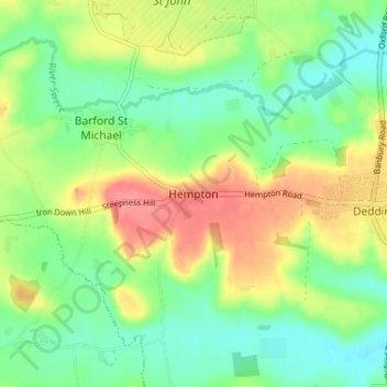
Navn: Topografisk kort Hempton, højde, terræn.
Gennemsnitshøjde: 112 m
Minimum højde: 83 m
Maksimal højde: 156 m
Andre topografiske kort
Klik på et kort for at se dets topografi, dets højde og dets terræn.
Horton-cum-Studley
United Kingdom > England > Oxfordshire > Cherwell District > Horton-cum-Studley
Gennemsnitshøjde: 71 m
Roman Meadow Banbury Country Park
United Kingdom > England > Oxfordshire > Cherwell District > Little Bourton
Gennemsnitshøjde: 103 m
Bicester
United Kingdom > England > Oxfordshire > Cherwell District
Bicester has expanded rapidly in recent generations due to the town's picturesque historical town centre, garden town layout, independent and high-street shops, restaurants, as well as a rail connection to Oxford. It also boasts imminent connection to Cambridge, as well as rail links to Birmingham and London.…
Gennemsnitshøjde: 77 m
Deddington
United Kingdom > England > Oxfordshire > Cherwell District
Clifton, Deddington and Hempton stand on a ridge of Jurassic ferruginous marlstone hills between the three watercourses. Clifton is about 1+1⁄2 miles (2.4 km) east of Deddington, at the eastern end of the ridge where it slopes down to the Cherwell. The ridges rises westward. Deddington is about 430 feet (130…
Gennemsnitshøjde: 107 m
The Lake
United Kingdom > England > Oxfordshire > Cherwell District > Hardwick
Gennemsnitshøjde: 120 m
Stoke Lyne
United Kingdom > England > Oxfordshire > Cherwell District > Stoke Lyne
Gennemsnitshøjde: 116 m
South Newington
United Kingdom > England > Oxfordshire > Cherwell District > South Newington
Gennemsnitshøjde: 139 m
Cropredy
United Kingdom > England > Oxfordshire > Cherwell District > Cropredy
Gennemsnitshøjde: 124 m