Geolocate

Topografisk kort Greene

Klik på kortet for at se højden.

Om dette kort

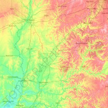
Navn: Topografisk kort Greene, højde, terræn.

Sted: Greene, Indiana, United States (38.32271 -87.69585 39.72271 -86.29585)

Gennemsnitshøjde: 186 m

Minimum højde: 115 m

Maksimal højde: 315 m

Andre topografiske kort

Klik på et kort for at se dets topografi, dets højde og dets terræn.

Marion County

United States > Indiana

Gennemsnitshøjde: 241 m

Pittsboro

United States > Indiana > Hendricks County

Gennemsnitshøjde: 285 m

Brown County State Park

United States > Indiana > Nashville

Brown County State Park is sometimes called "the Little Smokies" because of similarities with the Smokey Mountains. Activities available in the park include camping, fishing, biking, hiking, and seasonal horseback riding. Many of these activities are available all year. Overnight visitors may stay in the…

Gennemsnitshøjde: 224 m

Rensselaer

United States > Indiana > Jasper County

Gennemsnitshøjde: 203 m

DeKalb County

United States > Indiana

Gennemsnitshøjde: 272 m

Jasper

United States > Indiana > Dubois County > Jasper

Gennemsnitshøjde: 151 m

Miami County

United States > Indiana

Gennemsnitshøjde: 237 m

Newton County

United States > Indiana

Gennemsnitshøjde: 205 m

Cicero

United States > Indiana > Hamilton County

Gennemsnitshøjde: 252 m

White County

United States > Indiana

Gennemsnitshøjde: 210 m

Bourbon

United States > Indiana > Marshall County

Gennemsnitshøjde: 256 m

Versailles

United States > Indiana > Ripley County

Gennemsnitshøjde: 286 m

Porter County

United States > Indiana

Gennemsnitshøjde: 207 m

LaGrange County

United States > Indiana

Gennemsnitshøjde: 279 m

Martin County

United States > Indiana

Gennemsnitshøjde: 180 m

St. Joseph

United States > Indiana

Gennemsnitshøjde: 252 m

Sugar Creek

United States > Indiana

Gennemsnitshøjde: 223 m

Ohio County

United States > Indiana

Gennemsnitshøjde: 223 m

Carroll County

United States > Indiana

Gennemsnitshøjde: 210 m

Daviess County

United States > Indiana

The terrain of Daviess County is hilly, with its area completely devoted to agriculture or urban development. Its highest elevation (740'/266 meters ASL) is a rise one mile (1.6 km) NNE of Farlen. The county is drained by the White River flowing to the southwest, whose two main forks (East White and West…

Gennemsnitshøjde: 154 m

Pike County

United States > Indiana

Gennemsnitshøjde: 146 m

Lake Santee

United States > Indiana > Decatur County

Gennemsnitshøjde: 307 m

Akron

United States > Indiana > Fulton County

Gennemsnitshøjde: 260 m

Loogootee

United States > Indiana > Martin County

Gennemsnitshøjde: 166 m

Highland

United States > Indiana > Lake County

Gennemsnitshøjde: 188 m

Mount Summit

United States > Indiana > Henry County

Mount Summit was platted in 1854. It was named for its lofty elevation. A post office has been in operation in Mount Summit since 1869.

Gennemsnitshøjde: 330 m

Plymouth

United States > Indiana > Marshall County

Gennemsnitshøjde: 247 m

Logansport

United States > Indiana > Cass County

Gennemsnitshøjde: 203 m

Chalmers

United States > Indiana > White County

Gennemsnitshøjde: 214 m

Reynolds

United States > Indiana > White County

Gennemsnitshøjde: 211 m

Rocky Fork Lake

United States > Indiana > Parke County

Gennemsnitshøjde: 222 m

Clear Creek

United States > Indiana > Monroe County > Clear Creek

Gennemsnitshøjde: 218 m

Montezuma

United States > Indiana > Parke County

Gennemsnitshøjde: 153 m

Clear Lake

United States > Indiana > Steuben County

Gennemsnitshøjde: 321 m

Kendallville

United States > Indiana > Noble County

Gennemsnitshøjde: 303 m

Lowell

United States > Indiana > Lake County

Gennemsnitshøjde: 214 m

Avilla

United States > Indiana > Noble County

Gennemsnitshøjde: 294 m

Economy

United States > Indiana > Wayne County

Gennemsnitshøjde: 345 m

Brookston

United States > Indiana > White County

Gennemsnitshøjde: 208 m

Frankton

United States > Indiana > Madison County

Gennemsnitshøjde: 259 m

Pierceton

United States > Indiana > Kosciusko County

Gennemsnitshøjde: 280 m

North Judson

United States > Indiana > Starke County

Gennemsnitshøjde: 215 m

Farmland

United States > Indiana > Randolph County

Gennemsnitshøjde: 318 m

Edgewood

United States > Indiana > Madison County

Gennemsnitshøjde: 267 m

Mulberry

United States > Indiana > Clinton County

Gennemsnitshøjde: 237 m

Oak Park

United States > Indiana > Clark County

Gennemsnitshøjde: 140 m

Burns Harbor

United States > Indiana > Porter County

Gennemsnitshøjde: 189 m

Cambridge City

United States > Indiana > Wayne County

Gennemsnitshøjde: 292 m

Bremen

United States > Indiana > Marshall County

Bremen is located in northeastern Marshall County at 41°26′50″N 86°08′58″W / 41.447109°N 86.149342°W / 41.447109; -86.149342. It is at an elevation of 854 feet (260 m).

Gennemsnitshøjde: 252 m

Sweetser

United States > Indiana > Grant County

Gennemsnitshøjde: 257 m

North Salem

United States > Indiana > Hendricks County

Gennemsnitshøjde: 278 m

Osgood

United States > Indiana > Ripley County

Gennemsnitshøjde: 300 m

Lynn

United States > Indiana > Randolph County

Gennemsnitshøjde: 356 m

Arcadia

United States > Indiana > Hamilton County

Gennemsnitshøjde: 262 m

Worthington

United States > Indiana > Greene County

Gennemsnitshøjde: 162 m

Butler

United States > Indiana > DeKalb County

Gennemsnitshøjde: 265 m

Dale

United States > Indiana > Spencer County

Gennemsnitshøjde: 138 m

Greentown

United States > Indiana > Howard County

Gennemsnitshøjde: 258 m

Grand Calumet River

United States > Indiana > Lake County > Gary

Gennemsnitshøjde: 180 m

New Washington

United States > Indiana > Clark County

Gennemsnitshøjde: 214 m

Chandler

United States > Indiana > Warrick County

Gennemsnitshøjde: 129 m

Yorktown

United States > Indiana > Delaware County

Gennemsnitshøjde: 282 m

Eaton

United States > Indiana > Delaware County

Gennemsnitshøjde: 279 m

Albany

United States > Indiana > Delaware County

Gennemsnitshøjde: 290 m

Chesterfield

United States > Indiana > Madison County

Gennemsnitshøjde: 277 m

Hamilton

United States > Indiana > Steuben County

Gennemsnitshøjde: 283 m

Corunna

United States > Indiana > DeKalb County

Gennemsnitshøjde: 295 m

Altona

United States > Indiana > DeKalb County

Gennemsnitshøjde: 271 m

St. Paul

United States > Indiana > Decatur County

Gennemsnitshøjde: 258 m

Westport

United States > Indiana > Decatur County

Gennemsnitshøjde: 249 m

Millhousen

United States > Indiana > Decatur County

Gennemsnitshøjde: 277 m

New Point

United States > Indiana > Decatur County

Gennemsnitshøjde: 301 m

Hidden Valley

United States > Indiana > Dearborn County

Gennemsnitshøjde: 214 m

Saint Leon

United States > Indiana > Dearborn County

Gennemsnitshøjde: 288 m

Greendale

United States > Indiana > Dearborn County

Gennemsnitshøjde: 168 m

Boston

United States > Indiana > Wayne County

Gennemsnitshøjde: 344 m

Haw Creek

United States > Indiana > Bartholomew County > Hope

Gennemsnitshøjde: 209 m

Oldenburg

United States > Indiana > Franklin County

Gennemsnitshøjde: 288 m

Mount Carmel

United States > Indiana > Franklin County

Gennemsnitshøjde: 307 m

Galena

United States > Indiana > Floyd County

Gennemsnitshøjde: 232 m

Greenville

United States > Indiana > Floyd County

Gennemsnitshøjde: 245 m

Glenwood

United States > Indiana > Rush County

Gennemsnitshøjde: 332 m

Parker City

United States > Indiana > Randolph County

According to the 2010 census, Parker City has a total area of 0.57 square miles (1.48 km2), all land. It is located at an elevation of 1025 feet.

Gennemsnitshøjde: 312 m

Wabash

United States > Indiana > Wabash County

Gennemsnitshøjde: 233 m

Milford

United States > Indiana > Kosciusko County

Gennemsnitshøjde: 255 m

Kentland

United States > Indiana > Newton County

Gennemsnitshøjde: 207 m

Haubstadt

United States > Indiana > Gibson County

Gennemsnitshøjde: 141 m

Jonesboro

United States > Indiana > Grant County

Gennemsnitshøjde: 260 m

Argos

United States > Indiana > Marshall County

Gennemsnitshøjde: 251 m

Meridian Hills

United States > Indiana > Marion County

Gennemsnitshøjde: 237 m

Churubusco

United States > Indiana > Whitley County

Gennemsnitshøjde: 274 m

New Amsterdam

United States > Indiana > Harrison County

Gennemsnitshøjde: 151 m

New Middletown

United States > Indiana > Harrison County

Gennemsnitshøjde: 215 m

Gør dig klar til dit næste eventyr:

👜Vandtætte cykeltasker - Sikker opbevaring af udstyr på bagagebæreren
☀️Solcelleoplader - Miljøvenlig strøm til dine gadgets på lange ture
🍫Energibarer & snacks - Højenergi snacks til turen
🔭Kikkert - Kompakt kikkert til observation af landskab og dyreliv
🧦Vandresokker - Merinouldsokker der forhindrer vabler og holder fødderne tørre

Som Amazon-partner tjener denne side en kommission på kvalificerede køb uden ekstra omkostninger for dig.