
Topografisk kort Catcliffe
Klik på kortet for at se højden.
Catcliffe
The Catcliffe Glass Cone, part of the previous William Fenney's glassworks, is on Main Street. The centre of the village is dominated by a nine-arch viaduct that was built in 1901 to carry the Sheffield District Railway across the River Rother. Catcliffe Flash, to the south of the village, is a local nature reserve that is made up of a lake and marshland formed as the elevation of the land beside the River Rother dropped due to coal mining subsidence.
Om dette kort
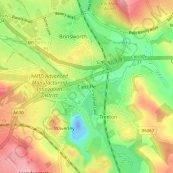
Navn: Topografisk kort Catcliffe, højde, terræn.
Gennemsnitshøjde: 58 m
Minimum højde: -38 m
Maksimal højde: 123 m
Andre topografiske kort
Klik på et kort for at se dets topografi, dets højde og dets terræn.
Hellaby
United Kingdom > England > Rotherham
With a Dutch impression that was influenced by the style common in the colonies, the Hall was built on a hill and hence an extra storey was required to obtain the height at the front elevation.
Gennemsnitshøjde: 113 m
Thorpe Salvin
United Kingdom > England > Rotherham
Thorpe Salvin is a village and a civil parish in the Metropolitan Borough of Rotherham in South Yorkshire, England, on the border with Nottinghamshire. It lies between Worksop and Harthill, and is located at an elevation of around 110 metres above sea level. At the 2011 Census, it had a population of 476, down…
Gennemsnitshøjde: 102 m
Woodsetts
United Kingdom > England > Rotherham
Woodsetts is a village and civil parish in the Metropolitan Borough of Rotherham in South Yorkshire, England, on the border with Nottinghamshire. It lies between the towns of Dinnington and Worksop at an elevation of around 60 metres above sea level, and has a population of 1,746 at the 2011 Census. The…
Gennemsnitshøjde: 70 m
Sheffield and South Yokshire Navigation
United Kingdom > England > Rotherham > Thrybergh
Gennemsnitshøjde: 39 m