
Topografisk kort Hull
Klik på kortet for at se højden.
Hull
Kingston upon Hull is on the northern bank of the Humber Estuary. The city centre is west of the River Hull and close to the Humber. The city is built upon alluvial and glacial deposits which overlie chalk rocks but the underlying chalk has no influence on the topography. The land within the city is generally very flat and is only 2 to 4 metres (6.5 to 13 ft) above sea level. Because of the relative flatness of the site there are few physical constraints upon building and many open areas are the subject of pressures to build.
Om dette kort
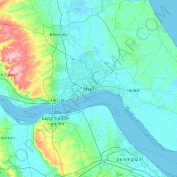
Navn: Topografisk kort Hull, højde, terræn.
Gennemsnitshøjde: 21 m
Minimum højde: -4 m
Maksimal højde: 168 m