
Topografisk kort Reigate
Klik på kortet for at se højden.
Reigate
Reigate is in central Surrey, around 19 mi (30 km) south of central London and 9 mi (14 km) north of Gatwick Airport. The town is in the Vale of Holmesdale, below the North Downs escarpment. The average elevation in the centre is 80 m (260 ft) above ordnance datum (OD) and the area is drained by the Wallace Brook and its tributaries, which feed the River Mole.
Om dette kort
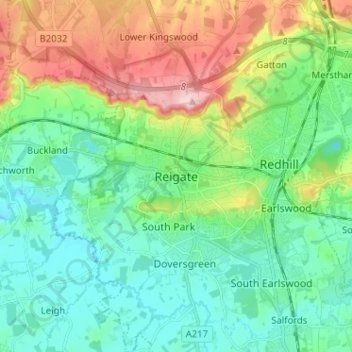
Navn: Topografisk kort Reigate, højde, terræn.
Gennemsnitshøjde: 100 m
Minimum højde: 43 m
Maksimal højde: 236 m
Andre topografiske kort
Klik på et kort for at se dets topografi, dets højde og dets terræn.
Lower Earlswood Lake
United Kingdom > England > Surrey > Reigate and Banstead > Redhill
Gennemsnitshøjde: 75 m
Redhill Common
United Kingdom > England > Surrey > Reigate and Banstead > Redhill
Gennemsnitshøjde: 92 m
Banstead Wood
United Kingdom > England > Surrey > Reigate and Banstead > Chipstead
Gennemsnitshøjde: 145 m
Reigate Park
United Kingdom > England > Surrey > Reigate and Banstead > Reigate
Gennemsnitshøjde: 80 m
Horley
United Kingdom > England > Surrey > Reigate and Banstead
Horley is at an altitude of around 54 m (177 ft) above mean sea level.
Gennemsnitshøjde: 58 m