
Tak fordi du støtter denne side ❤️
Giv en donation
Giv en donation
Gør dig klar til dit næste eventyr:
Som Amazon-partner tjener denne side en kommission på kvalificerede køb uden ekstra omkostninger for dig.
Topografisk kort Houston
Klik på kortet for at se højden.
Tak fordi du støtter denne side ❤️
Giv en donation
Giv en donation
Gør dig klar til dit næste eventyr:
Som Amazon-partner tjener denne side en kommission på kvalificerede køb uden ekstra omkostninger for dig.
Om dette kort
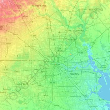
Navn: Topografisk kort Houston, højde, terræn.
Sted: Houston, Harris County, Texas, Amerikas Forenede Stater (29.53707 -95.90974 30.11035 -95.01205)
Gennemsnitshøjde: 25 m
Minimum højde: -3 m
Maksimal højde: 98 m
Tak fordi du støtter denne side ❤️
Giv en donation
Giv en donation
Gør dig klar til dit næste eventyr:
Som Amazon-partner tjener denne side en kommission på kvalificerede køb uden ekstra omkostninger for dig.