
Topografisk kort Tarporley
Klik på kortet for at se højden.
Om dette kort
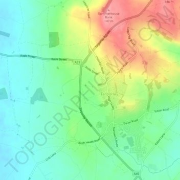
Navn: Topografisk kort Tarporley, højde, terræn.
Sted: Tarporley, Cheshire West and Chester, England, United Kingdom (53.14580 -2.69490 53.17415 -2.64515)
Gennemsnitshøjde: 85 m
Minimum højde: 47 m
Maksimal højde: 149 m
Andre topografiske kort
Klik på et kort for at se dets topografi, dets højde og dets terræn.
Dutton Locks
United Kingdom > England > Cheshire West and Chester > Acton Bridge > Dutton
Gennemsnitshøjde: 28 m
Countess of Chester Country Park
United Kingdom > England > Cheshire West and Chester > Chester
Gennemsnitshøjde: 21 m
Delamere Forest
United Kingdom > England > Cheshire West and Chester
This part of Delamere Forest is undulating in character, with elevations predominantly in the range 60–90 metres. It is composed of numerous hummocks and peatland basins, some of which are glacial in origin while others have been created by sand extraction. The basins form lakes and mosses (bogs) within the…
Gennemsnitshøjde: 90 m
Bolesworth Castle
United Kingdom > England > Cheshire West and Chester > Harthill > Broxton
Gennemsnitshøjde: 80 m
Bolesworth Fish Pond
United Kingdom > England > Cheshire West and Chester > Harthill > Broxton
Gennemsnitshøjde: 75 m
Wirral Country Park
United Kingdom > England > Cheshire West and Chester > Neston > Windle Hill
Gennemsnitshøjde: 49 m
Peckforton Castle
United Kingdom > England > Cheshire West and Chester > Beeston
Peckforton Castle stands in a wooded area near the northern extremity of Peckforton Hills at an elevation of 469.2 feet (143 m). The land falls steeply downwards to the north and the west of the castle, and the Sandstone Trail, a long-distance footpath, runs along the base of these slopes. The ruins of Beeston…
Gennemsnitshøjde: 83 m
Eddisbury Hill
United Kingdom > England > Cheshire West and Chester > Delamere
Gennemsnitshøjde: 103 m
Dutton Small Lock (Disused)
United Kingdom > England > Cheshire West and Chester > Acton Bridge > Dutton
Gennemsnitshøjde: 28 m
Broken Cross
United Kingdom > England > Cheshire West and Chester > Lostock Green
Gennemsnitshøjde: 28 m
Stamford Bridge
United Kingdom > England > Cheshire West and Chester > Great Barrow
Gennemsnitshøjde: 24 m
Eddisbury Hill Fort
United Kingdom > England > Cheshire West and Chester > Delamere
Gennemsnitshøjde: 103 m
Bostock Green
United Kingdom > England > Cheshire West and Chester > Bostock Green
Gennemsnitshøjde: 36 m
Meadowbank
United Kingdom > England > Cheshire West and Chester > Winsford > Meadowbank
Gennemsnitshøjde: 40 m
Delamere Forest
United Kingdom > England > Cheshire West and Chester
This part of Delamere Forest is undulating in character, with elevations predominantly in the range 60–90 metres. It is composed of numerous hummocks and peatland basins, some of which are glacial in origin while others have been created by sand extraction. The basins form lakes and mosses (bogs) within the…
Gennemsnitshøjde: 90 m
Black Diamond Park
United Kingdom > England > Cheshire West and Chester > Chester
Gennemsnitshøjde: 21 m