
Topografisk kort Shocklach
Klik på kortet for at se højden.
Om dette kort
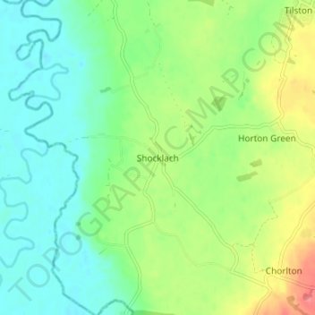
Navn: Topografisk kort Shocklach, højde, terræn.
Gennemsnitshøjde: 30 m
Minimum højde: 7 m
Maksimal højde: 73 m
Andre topografiske kort
Klik på et kort for at se dets topografi, dets højde og dets terræn.
Great Boughton
United Kingdom > England > Cheshire West and Chester > Great Boughton
Gennemsnitshøjde: 28 m
Countess of Chester Country Park
United Kingdom > England > Cheshire West and Chester > Chester
Gennemsnitshøjde: 21 m
Burwardsley
United Kingdom > England > Cheshire West and Chester > Burwardsley
Gennemsnitshøjde: 113 m
Frodsham
United Kingdom > England > Cheshire West and Chester
Several faults run roughly northwest–southeast through the area, notably the Overton Fault, which roughly parallels the B5439 and B5152 roads, and the Frodsham Fault, which runs north from the vicinity of Crowmere to the mouth of the River Weaver. Both of these faults and others in the area downthrow to the…
Gennemsnitshøjde: 49 m
Bolesworth Fish Pond
United Kingdom > England > Cheshire West and Chester > Harthill > Broxton
Gennemsnitshøjde: 75 m
Wirral Country Park
United Kingdom > England > Cheshire West and Chester > Neston > Windle Hill
Gennemsnitshøjde: 49 m
Peckforton Castle
United Kingdom > England > Cheshire West and Chester > Beeston
Peckforton Castle stands in a wooded area near the northern extremity of Peckforton Hills at an elevation of 469.2 feet (143 m). The land falls steeply downwards to the north and the west of the castle, and the Sandstone Trail, a long-distance footpath, runs along the base of these slopes. The ruins of Beeston…
Gennemsnitshøjde: 83 m
Little Stanney
United Kingdom > England > Cheshire West and Chester > Ellesmere Port
Gennemsnitshøjde: 21 m
Dutton Small Lock (Disused)
United Kingdom > England > Cheshire West and Chester > Acton Bridge > Dutton
Gennemsnitshøjde: 28 m
Little Leigh
United Kingdom > England > Cheshire West and Chester > Little Leigh
Gennemsnitshøjde: 38 m
Black Diamond Park
United Kingdom > England > Cheshire West and Chester > Chester
Gennemsnitshøjde: 21 m