
Topografisk kort Caterham
Klik på kortet for at se højden.
Caterham
In 1840 Caterham contained a total of 477 residents (figures taken from that census, compiled in an 1848 topographical encyclopedia) and in 1848 468 acres (189 ha) of its 2,386 acres (966 ha) were common land. Similar to today, 175 acres (71 ha) mostly steeper acres were woodland.
Om dette kort
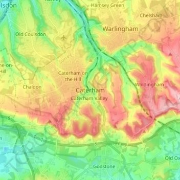
Navn: Topografisk kort Caterham, højde, terræn.
Sted: Caterham, Tandridge, Surrey, England, CR3 6XS, United Kingdom (51.24197 -0.11710 51.32197 -0.03710)
Gennemsnitshøjde: 157 m
Minimum højde: 71 m
Maksimal højde: 269 m
Andre topografiske kort
Klik på et kort for at se dets topografi, dets højde og dets terræn.
Warlingham
United Kingdom > England > Surrey > Tandridge
Elevations vary from 110m AOD at Woldingham Road, at the southernmost point of the parish, with a gentle increase in height through the village along the main road heading to the southeast, to the highest elevation (199.6m) at Limpsfield Road.
Gennemsnitshøjde: 163 m